Hurricane Ridge on the Washington north coast had been fabulous and the coast a nice visit with the Pacific Ocean. We had recently decided not to head off toward Vancouver in British Columbia-just not enough time- so onto the road leading toward Tacoma, and Seattle, and and Mt. Rainier National Park, WA July 6-7
On Dan and I traveled, car and bike, to the town of Fife, south of Seattle, WA, where a BMW dealer is
located. Dan needed a service visit on the BMW. The trip to Fife allowed us to drive more of the north coast before heading south toward the city. When we arrived near Tacoma and had to use rt. 5, our leisurely pace of travel ramped up a bit.
While the bike was serviced- Dan needed new tires and an oil change- we took the car to Mt. Rainier National Park on the recommendation of a barber who cut Dan's hair in Fife. Another "You're so close, don't miss it", attraction.
While the bike was serviced- Dan needed new tires and an oil change- we took the car to Mt. Rainier National Park on the recommendation of a barber who cut Dan's hair in Fife. Another "You're so close, don't miss it", attraction.
So, rather than sit around the Motel 6 for the day we headed off to get closer to Mt. Rainier; we could actually see the top part of Rainier from Fife.
INFORMATION from MT. RAINIER'S website
Mount Rainier has five developed areas: Longmire, Paradise, Ohanapecosh, Sunrise, and Carbon/Mowich. Although the level of development in these areas ranges from basic -little more than a campground and picnic area- to extensive -hotel, restaurant, visitor center, campgrounds and picnic areas- each can serve as a base for exploring the rest of the park.
Mount Rainier National Park encompasses 235,625 acres on the west-side of the Cascade Range, and is located about 100 kilometers (50 miles) southeast of the Seattle-Tacoma metropolitan area. Mount Rainier National Park is approximately 97 percent wilderness and 3 percent National Historic Landmark District and receives approximately 2 million visitors per year.
At 14,410 feet, Mount Rainier is the most prominent peak in the Cascade Range. It dominates the landscape of a large part of western Washington State. The mountain stands nearly three miles higher than the lowlands to the west and one and one-half miles higher than the adjacent mountains. It is an active volcano that last erupted approximately 150 years ago.
The park is part of a complex ecosystem. Vegetation is diverse, reflecting the varied climatic and environmental conditions encountered across the park's 12,800-feet elevation gradient. Approximately 58 percent of the park is forested, 23 percent is subalpine parkland, and the remainder is alpine, half of which is vegetated and the other half consists of permanent snow and ice. Forest ages range from less than 100 years old on burned areas and moraines left by receding glaciers to old-growth stands 1,000 or more years. Some alpine heather communities have persisted in the park for up to 10,000 years.
Species known or thought to occur in the park include more than 800 vascular plants 159 birds, 63 mammals, 16 amphibians, 5 reptiles, and 18 native fishes. The park contains 26 named glaciers across 9 major watersheds, with 382 lakes and 470 rivers and streams and over 3,000 acres of other wetland types. Of these vertebrates, there are 4 federally listed threatened or endangered species known to occur in the park, including 3 birds and 1 fish. Four other species historically occurred in the park, but their present status is unknown including: gray wolf, grizzly bear, Canada lynx, and Chinook salmon.
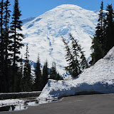
For our trip we went south from Fife to rt. 401 and entered the park at White Water to make sure to see Sunrise Point . In checking the website, the road to Sunrise was recently opened. The climb in the carwas to almost 7000 feet with one stop at a lake overlook, and then continuing on up. There were plenty of cars at the Point parking lot. I played with a family whose kids were sliding on the huge snowbanks.
After this visit we drove on down the mountain and continued on through and around Steven Canyon, then ascended to Paradise. Paradise has a restaurant and hotel andf is the place, other than Sunrise, where most teams of climbers begin their ascents. Their was snow at Paradise, too. We drove by three of the foxes in the pictures and met, thanks to two tourists who spotted them, the Horey Marmots. With window open we heard their whistle-like piercing noise, but did not know what had made it.
By now it was late enough for dinner. We continued on our semi-circle on the south road around the mountain toward Longmire and the lodge for dinner, then returned the 80 miles or so to Fife.
Many people visit this park intending to climb to Rainier's Summit. Here is some data about climbing.
At 14,410 feet, Mount Rainier is the most prominent peak in the Cascade Range. It dominates the landscape of a large part of western Washington State. The mountain stands nearly three miles higher than the lowlands to the west and one and one-half miles higher than the adjacent mountains. It is an active volcano that last erupted approximately 150 years ago.
The park is part of a complex ecosystem. Vegetation is diverse, reflecting the varied climatic and environmental conditions encountered across the park's 12,800-feet elevation gradient. Approximately 58 percent of the park is forested, 23 percent is subalpine parkland, and the remainder is alpine, half of which is vegetated and the other half consists of permanent snow and ice. Forest ages range from less than 100 years old on burned areas and moraines left by receding glaciers to old-growth stands 1,000 or more years. Some alpine heather communities have persisted in the park for up to 10,000 years.
Species known or thought to occur in the park include more than 800 vascular plants 159 birds, 63 mammals, 16 amphibians, 5 reptiles, and 18 native fishes. The park contains 26 named glaciers across 9 major watersheds, with 382 lakes and 470 rivers and streams and over 3,000 acres of other wetland types. Of these vertebrates, there are 4 federally listed threatened or endangered species known to occur in the park, including 3 birds and 1 fish. Four other species historically occurred in the park, but their present status is unknown including: gray wolf, grizzly bear, Canada lynx, and Chinook salmon.
For our trip we went south from Fife to rt. 401 and entered the park at White Water to make sure to see Sunrise Point . In checking the website, the road to Sunrise was recently opened. The climb in the carwas to almost 7000 feet with one stop at a lake overlook, and then continuing on up. There were plenty of cars at the Point parking lot. I played with a family whose kids were sliding on the huge snowbanks.
After this visit we drove on down the mountain and continued on through and around Steven Canyon, then ascended to Paradise. Paradise has a restaurant and hotel andf is the place, other than Sunrise, where most teams of climbers begin their ascents. Their was snow at Paradise, too. We drove by three of the foxes in the pictures and met, thanks to two tourists who spotted them, the Horey Marmots. With window open we heard their whistle-like piercing noise, but did not know what had made it.
By now it was late enough for dinner. We continued on our semi-circle on the south road around the mountain toward Longmire and the lodge for dinner, then returned the 80 miles or so to Fife.
Many people visit this park intending to climb to Rainier's Summit. Here is some data about climbing.
A PARTIAL LIST OF CLIMBING STATISTICS from website
Year Number of climbers Number successful
1852 (a) 4 0
1854 (a) 2 2
1857 5 0
1870 (b) 5 4 The first recorded successful conquest of the mountain
Year Number of climbers Number successful
2000 13114 6083
2001 11167 5171
2002 11313 5553
2003 9714 5295
2004 9251 4951
2005 8972 4604
2006 9154 5787
2007 8976 4707
2008 10180 5682
2009 10616 6438
2010 10643 4920
(a) Reported in Mountain Fever, Haines
(b) First recorded climb of Mount Rainier
Some of those who attempt the hike are turned back by weather, preparation and other factors. Rainier has a fully trained and experienced Ranger staff.
Some of those who attempt the hike are turned back by weather, preparation and other factors. Rainier has a fully trained and experienced Ranger staff.
THE LOG OF SEARCH AND RESCUE 2010
Highlights
The weather was the leading factor in 2010. Until late March, the snowpack at Paradise was about 75% of normal. It was
looking like it may be an early climbing season. April, May, and June were much cooler and wetter than normal. The
snowpack recovered and eventually topped out around 200%. Weather and avalanche conditions curtailed many climbers’
summit plans until late June. However, after the fourth of July, the weather became more stable and climbing operations
were normal after that.
There were an unusual number of search and rescue incidents this season, especially lower down on the mountain. This
can partly be explained by the unseasonably cool and wet weather. Poor weather leads to many of the major incidents on
Mt. Rainier. The cool weather also pushed unstable winter and spring-like climbing conditions (the physical snow and ice
conditions) into a period of higher use where the conditions are normally more firm, stable, and reliable. There were 26
search and rescue incidents in 2009 (19 climbing related). In fiscal year 2010, there were 41 search and rescue incidents (20
climbing related).
The climbing program had not replaced two supervisory rangers for almost 4 years. These two positions were filled in the
spring of 2010. These two positions are on-hill and high camp supervisors for the climbing ranger program and act as the
district ranger in his absence.
Climbing rangers began their summer season on April 5th
, almost 5 weeks sooner than normal. Climbing activity usually
increases almost exponentially after mid-May, which makes it difficult to conduct training. The early start date made it far
simpler to train in core skill areas.
A comprehensive training program was coordinated for the climbing rangers which included a 5-day technical rope rigging
class, an EMT refresher and skills test, ski patrol litter training at Crystal Mountain, aviation refreshers and trainings with
the military, Incident Command System, GPS, and Operational Leadership – to name a few. This helped prepare climbing
rangers for an intense season of climbing and also rescue operations.
There were three international entities that came to Mt. Rainier to experience our climbing (and rescue) programs. Ang
Tshering Lama, a Nepali national, volunteered with the climbing rangers at high camps Muir and Schurman. Climbing
rangers also hosted representatives from the Seoul Mountain Rescue Association for several days. Climbing rangers also
coordinated with the US State Department for a day-visit of professionals from Chengdu, China to tour our climbing
program. These visits help Mt. Rainier develop its image as a leader in climbing management around the world.
International Mountain Guides part-owner, George Dunn achieved his 500th summit on Mt. Rainier (the current record).
George’s experience, cooperation, and leadership are instrumental in creating an exceptional work and climbing environment at Mt. Rainier.
The Mountaineering Ranger District
The mountaineering ranger district is approximately 70,000 acres of Mt. Rainier’s 250,000 acres, or roughly everything
above tree line up to the summit. Aside from an area of roughly 1 acre that includes Camp Muir, the entire district is
designated wilderness. There are two management policies that affect wilderness management in the park.
The Organic Act (1916) established the National Park Service. It dictated the NPS’s mission which stated that its purpose is
to, “… conserve the natural and historic objects and the wildlife therein, and provide for the enjoyment of the same, in such Mount Rainier National Park Mountaineering Report 2010
manner and by such means that will allow for the enjoyment of future generations.”
And the Wilderness Act (1964)
And the Wilderness Act (1964)
established that, “ … A wilderness, in contrast with those areas where man and his own works dominate the landscape, is
hereby recognized as an area where the earth and its community of life are untrammeled by man, where man himself is a
visitor who does not remain.” Four principles were defined, roughly summarized; 1) where the imprint of man's work
substantially unnoticeable; (2) where the land has outstanding opportunities for solitude; (3) is composed of least five
thousand acres; (4) may also contain ecological, geological, or other features of scientific, educational, scenic, or historical
value.
It is for these management directives that our climbing program exists as well as to provide for visitor education,
information, and resource protection.
Wilderness visitor use in the mountaineering district is disproportionate to its size. Most of Mt. Rainier’s overnight
wilderness (both climbing and hiking) is associated with climbing.
Roughly 10,500 climbers attempted Mt. Rainier in 2010,
Roughly 10,500 climbers attempted Mt. Rainier in 2010,
as opposed to 9,500 people who used the lower regions of the park for overnight backpacking. The extent of day use is not
well-known as there have only been intermittent studies at various trailheads, but summer day-use into the alpine zones is
probably very comparable to day-use into the backcountry zones.
A simple study done with a trail counter at Pebble Creek
A simple study done with a trail counter at Pebble Creek
(1/2 way up to Camp Muir) in 2010 roughly compared traffic entering the park to passers-by at Pebble Creek, which on
some days was roughly 10% of the entrance station volume!
The Mt. Rainier climbing program attempts to manage the alpine zones consistent with these service and resource
management policies. It seeks to preserve the wilderness character, maintain solitude, discourage and eliminate impacts,
and help users understand its purpose and intent.
The Climbing Program and its Rangers
On no other mountain in the United States, are there so many people in technical glaciated terrain for so many days. This
creates management responsibilities the National Park Service must address.
On top of managing wilderness, the climbing program seeks to promote visitor education and safety by registering,
contacting, and providing information to climbers before, during, and after their visit. It is required by US law (36 CFR 7.5)
to register for (and check out of) each climb. Of the approximately 4,500 climbers who are associated with the commercial
guide services, the remaining 6,100 people require some level of briefing or interaction during the registration process.
Click here to see a map of the Rainier National Park and its Glaciers - but you will lose the blog so maybe go back to the map later.
Scenery of Mt. Rainier (14,411’) and some of its twenty-six named glaciers
 |
| Washington,Rainier National Park |


No comments:
Post a Comment