Wednesday, August 31, 2011

LONG TIME NO ENTRIES- 2011 Catch up

August 2011

Dan and I were again living at E dock of the Titusville Municipal Marina in Florida.  We loved our trip out West; the scenery of our wonderful National Parks and excitement of the trip by motorcycle- but now, August 5th, we were glad to be back in Sea Star's soft bed and luxurious salon after camping and minimal facility hotels since April. Sea Star is the name of our 45 foot Island Packet sailboat.

We both avoided talking about or even considering leaving again as it was hurricane season and we needed to be vigilant. Of course after four months away we had the regular, and sometimes boring things we had to catch up on.  Sea Star had survived our time away well.  We ran a room a.c. from her largest hatch in the hot, Florida summer.

 We had kind of hurried back from our last stop in Colorado because Florida was expecting a tropical storm named Emily. It was the hurricane season after all.  We had picked Titusville Municipal Marina to store and hopefully protect Sea Star during these events, and we have conscientious dock mates; always on watch, but still...

  Emily, August 5th, thankfully did not develop into a large enough storm to disturb us, and life went on with Emily dropping buckets of rain on her path North--Life went on as usual until the report of Tropical Storm Irene became the topic of the day and caught the attention of boaters.   


G2 at 16 and Aunt Bev have a birthday party.

G2 with girlfriend Sam


In the storage locker down the road- camping and motorcycle gear.

Always beautiful at sunset in Florida.

This larger boat helped block the wind for one of our storms.

The main outcome of Irene for our area was in high seas, rip currents and inland rain- so we felt we’d been lucky again.  My family in Massachusetts had greater destruction from the storm than we felt in Titusville on August 25-26.  Of course Irene was not a gentle presence in Puerto Rico or the Bahamas, where she hit with a vengeance as a category 1 hurricane.  Irene caused heavy rains, flooding, and trees to fall in many areas all up the Eastern US. to the Canadian Maritimes, spawning a few tornados as she swept through. 


Finally the boat and car are cleaned out!


I think Patty is dancing because she is waiting for Grandson Donovan to spend his first weekend with Grammy and Gary

Some of our dock mates joined in the fun with pictures to welcome him.


But some, like younger teenager, another Sam, drew a regular project! She drew an entire moon-landing scape, complete with waving astronaut and American flag.

August was lots of boat cleaning. Here dockmates are wondering how to get all that-onto their sailboat.

What was not a bit boring is the life at Titusville Marina, and we simply fell right back in for awhile; the rest of August and September, and had fun with friends. I joined a health club and Dan and I went riding locally.

Next entry September and October 2011


Hoodoos, Sleeping Rainbow, Bridges over troubled Waters May 31-June 7

JUST TRAVELING

(UTAH -Bryce Canyon National Park, rt 12 to Capital Reef National Park, rt. 95 to Natural Bridges National Monument, Valley of the Gods)


BRYCE CANYON NATIONAL PARK


After our few days of rest in Kanab, I just mean on a bed, we're all packed up and riding/driving rt.89 north to Bryce Canyon National park. Along the way we saw quite a bit of flooding in the sreams and creeks along the highway as we made for higher ground.  Arriving early in the day we traveled past Red Canyon, and on to t Bryce Campground, which, even in the early afternoon was filling fast.  We set up camp, made a fire and enjoyed the cool evening talking with a fellow camper.

The next day was spent riding the bike to explore the overlooksand do a little shopping at the concession camp store the Parks may have.  We bought more of our favorite camp food.  Made and packaged in Oregon, Mountain House brand dried dinners, yummy-kinda.  The following day we hiked into the canyon to see, up close, the strange formations that eroded a special way in Bryce and vicinity and are named Hoodoos.

Geologically speaking from Ask.com: Hoodoo

"The big geologic dictionary says that only a tall formation should be called a hoodoo; any other shape—a camel, say—is called a hoodoo rock. The defining feature of either one of these is that its shape is bizarre or fantastic. And a proper hoodoo (the word is the same as voodoo), it seems, must look like an image of the spirits that populate the voodoo cosmology—that is, it needs to be spooky. That's a curious eruption of folklore in a scientific glossary, and just another reason to love geology."

Our long walk and hike back out was a highlight and well worth the hours of effort.  We started from an overlook point called Sunrise, entered the Queens Garden and regained the rim at Sunset Point. The parks often offer Ranger led or self led excursions.  We opted to self-guide and take our time walking at our pace.  Since I stop frequently for pictures, that allows a relaxed approach. Still, tourists were everywhere.  I especially noted, as we passed them on the hike up, some Chinese? tourists who were just not dressed appropriately; fancy nylon dresses but especially the womens' high-soled flip-flop type shiny gold or sequined platform shoes!
They were warned  by the Ranger but they made the climb anyway.


Leaving the park after the walk and a coin-operated shower we made a nightime stop somewhere, but in a nice hotel, and moved on in the morning to see Capital Reef, the next Natioal Park on our treck east and then north heading towards Moab.

CAPITAL REEF NATIONAL PARK


The Native American name for Capitol Reef, the "Sleeping Rainbow," seems to me more picturesque than the name Capitol Reef National Park, which takes its name from a segment of the Waterpocket Fold, a geologic form, with many domes of white Navajo sandstone over red Wingate sandstone cliffs, infused with purples and hints of blue and yellow and white that apparently resembled the domes of the U.S. and other capitol buildings to the namers. 

 This one hundred mile length of north-south upthrust ridge of slickrock called the Waterpocket Fold reaches from Thousand Lake Mountain to Lake Powell. The area of the National Park that can be explored by paved road is probably about 20 miles.  There are some graveled roads leading farther into the canyons now being built, so there was some construction.  We drove through I think on a Sunday, so we avoided the construction. Like every day in Texas, Arizona and Utah so far- no rain and warm in the daytime.  Nights however can be cool and they were in May-June.


Before the fourteenth century, I read, the now Fremont River area was occupied by prehistoric people known as the Fremont Indians, who scratched petroglyphs and painted pictographs on rock walls near trails and waterways. In 1878 Franklin D. Richards, a Mormon settler, established Fruita ,an orchard where park headquarters is now located.  Visitors can explore the farmhouse, a museum and see the non-producing older orchard areas.  The feel of Capital Reef was friendly with a large picnic and play area provided for family usage in the park.  There was a bit of road construction apparently going on but not on Sunday.


We left Capital Reef behind, its campground was full, not knowing how far we could get to or where we could camp. Only a few towns were listed on our map and the road actually was quite deserted away from the park, but scenic. We pulled into a Bureau of Land Management campsite, and although it was a nice site, it was close to the road and we didn't feel comfortable there, so we moved on.  The landscape changed to what I can only describe as the same cliffs and canyons that we'd seen other places in Utah, but now they were all shades of grey and certainly formidable looking- knd of like pictures of a lunar landscape.

We headed into the town of Hanksville toward evening and pulled both of our vehicles into a Rodeway Motel.  There were no other vehicles there, but when I spoke with the manager she said they were "all full."  She went on to explain that once a year, and this was the time, the town hosts a Robot festival where teams arrive from major Universities around the country; MIT was there and other technical colleges, to have robot competitions out in the desert!  In the middle of nowhere is a good description.

Anyway that one motel was full and so was another closer in to the -three buildings and a gas station town- but there was a private campground mostly filled with RVs and trailers. They had tent space and bonus, a nice restaurant, and although we would have loved to see what was going on in the desert, it was not an open event and the few people we talked to just ignored the whole thing.  Later the teams returned from the desert to the restaurant and we heard noise until 3:00AM.


EASTWARD to Natural Bridges National Monument

We headed off in the morning after breakfast at the restaurant, east on rt. 24 to rt. 95 and about 60  scenic miles later arrived at our Natural Bridges National Monument.  Natural Bridges is an area of canyons and mesas where, due to the raging rivers, fabulous formations have developed over time by running water through the sandstone.  In Natural Bridges, we learned that bridge formation and arch formation are similar but there are many more arches formed. Bridges are formed over water and arches can be formed anywhere water has been.


 Bridges National Monument is famous for  three named bridges a visitor can view from overlooks or they may hike to examine them, taking care not to hike into canyons in the Spring when the snow is melting quickly from the high mountains so flash floods are likely.
The three naturally formed bridges viewed off the paved 8 mile loop road are the Sipapu Bridge, Kachina Bridge and the one we hiked a mile to see, Owachomo Bridge- meaning rock pile.  In a restaurant not far from the Monument there is a picture I tried to find a copy of on-line ; a group of mounted cowboys; men whose names were famous in the area as well as government troops posing on the Owachomo Bridge.  There were as many as fifty people on the span in the picture.  Today no one is allowed on the bridge for safety reasons and to prevent damage.

Here are some pictures of the Bryce Canyon, Capital Reef and Natural Bridges with some driving scenery before and in between.
Dont forget to explore the photos with zoom.

8 Bryce , rt 12, Natural Bridges Monument, Mexican Hat

VALLEY OF THE GODS- MEXICAN HAT
Mexican Hat is a town and a motorcycle ride we were told about by another biker from New Mexico.  We visited the area using the car in a quick one day visit.  The maps showed construction on the road over the mountain and a dirt road to explore Valley of the Gods- which sounded like a wonderful place to visit.  Leaving our camp at Natural Bridges we traveled down, around and around the mountain on rt. 261.  At the botton of the canyon was the seven mile gravel road called Valley of the Gods.  It is said to remind people who have visited both, of Monumant Valley where Dan and I did not visit.  We marveled at the fabulous formations, monuments if you will, we could explore for all sides from the dirt road.  Even the road was fun to drive because of steep rises and plunging falls as we passed some of the formations, old washes, dried creek beds.  After a few hours of exploration on the 7 mile road, we continued on to the town of Mexican Hat.  The rock formation definately showed us we were near the town of under 100 inhabitants. We drove in to the one gas station, saw tourists ready to ride/float the San Juan River, ate at a small local cafe and discovered the Polygamy Porter brand of beer; low on alchohol at 4.5% alcohol content but fun to read the label! (Remember the Pipe Springs hiding of the extra wives at the fort)

Dan and I were literally blown away when we exited the cafe and headed, head down to avoid the dust and wind, to our car.  Soon we arrived at the entrance road to Gooseneck State Park and the meandering San Juan River, spent a very short time there and headed back to 261 and Natural Bridges.  When we arrived there was still lots of wind at the campsite.  We noticed we had more than a bit of fine, red sand in our tent, covering sleeping bags and stuck in the mesh of our tent!  We cleaned it up but the wind still blew all night and we needed to clean up again in the morning, as well as refill our water bottles three miles down hill at the visitors' center and off we headed east to rt. 191 and the town of Monticello, Utah.


STILL IN UTAH and headed South next.


Saturday, August 27, 2011

UTAH- GRAND VISTAS and RED EARTH May 29- June 1, 2011


May 29- June 1, 2011
(Kanab, Zion National Park, Pipe Spring Monument, Toroweep GC)


We drove out of the Grand Canyon North Rim past the towns of Jacub Lake, and Fredonia using 89A through the Vermilion Cliffs and headed on toward UTAH. Our next park was to be Zion National Park in Utah. After the cold nights (low 40s) at the North Rim and camping through the Grand Canyon we were ready for a bit of comfort. We found a small, out of the way motel called the Sun and Sands Motel in the town of Kanab, checked the rooms for cleanliness and decided the price was right and what the heck we could stay two nights for the price of one. Not only was Sun and Sand affordable, but the friendly manager Wayne, was knowledgeable about the sights in the area.


After a bit of research, we realized there were many places we wanted to visit in UTAH. Utah has many areas and acres of land designated as National Parks. Confusingly the name usually has “canyon” in it, in fact we found Zion National Park was also referred to as Zion Canyon and contained an area called Kolab Canyon. Then there was Canyonlands National Park and Red Canyon, Moab, Arches, Natural Bridges….too many to name, much less figure out a route. Well, tomorrow’s plan would be Zion National Park.

ZION National Park


In Zion, park elevations range from 3600 to 8700 feet on the Colorado Plateau, and so provide many different habitats for many different critters; tiny pinon mice, golden eagles, mountain lions have their niches. As we heard at the Grand Canyon, there are Condors nesting above the canyons, as well as Peregrine Falcons. There are areas of Ponderosa pine, Aspin, cliffrose, a lovely pink bloom, and mesquite. The trailheads to the rim environment, into the canyons and along the Virgin River allow heartier humans to immerse themselves fully into the exploration. Zion’s special formations are water formed due to freeze, thaw multiple times over time and river erosion. Because parts of Zion have been used in the past for grazing and farming this park is not “pristine,” but still has a lot to offer.


We entered the park, with a short line of other cars, from rt. 89 and traveled rt. 9 to the East entrance. In Zion there is a 15 mile road heading north on which tourists (like us) take a free shuttle bus to visit the eight river-carved viewing areas through the bottom of the Zion Canyon. The canyon walls become higher and higher as the bus moves slowly to the Virgin River and the Narrows riverside walk.


Returning to the car and the main road, just outside the park road to the west, are restaurants, hotels, and gift shops selling native crafts and other souvenirs. We drove through the area, stopped and checked out the birds at a very nice town park rested on a picnic table for awhile and continued on another 80 miles on Indian land to Kolob Terrace Rd. to Lava Point and Blue Springs Reservoir where it was too muddy to 4x4) wanting to move away from the crowds.


It worked. We needed the 4x4, but the red, dirt road was well maintained. It passed through private farms outlined with fences and over cattle guards (metal road grates to prevent free-ranging cattle from leaving their usual area), high onto the plateau above Zion Canyon. We kept on on the private road and found the Blue Springs Reservoir where the locals fish, camp and cruise in small boats.


Here are some pics from Zion. These pictures are from Dan’s camera. My battery was dead; one of the drawbacks to camping.

Zion National Park


We were lucky to have our options in transportation. Sometimes we found too late that we shouldn’t take the bike to some of our destinations. Today, according to Wayne, was one of those times, we would be on dirt roads, so we headed to the Pipe Spring National Monument by car on rt.389 finding ourselves going through a time warp as well as a one hour time change and back in Arizona -on land managed by the Kaibab Band of Paiute Indians.

The visitors’ center was staffed by casually-dressed Paiute tribe members, as opposed to the usual green formal ranger gear we had become accustomed to. We absorbed information about the pre-Paiutes, the later Mormon settlers and the use of this important water source area as a frontier fort as well as a Mormon tith farm.


PIPE SPRING National Monument
Paraphrased from visitor literature

The area of the Arizona Strip, located between the Grand Canyon and Vermilion Cliffs has limited but important water resources. The groups known to have been located in this area were the Ancestral Puebloans until about 3000BC the Paiute Indians until the 1700s, when missionaries and explorers like Jacob Hamblin 1858 and John Wesley Powell in 1870 visited the area. Mormon settlers from Salt Lake City settled and farmed the area before and after that time. Water, the Spring, being crucial to the before friendly Indians, caused the Fort to be built in 1868 by the Mormon Militiamen. In 1870 Brigham Young and Anson Winsor paced off the new ranch that would be built as a tith ranch (at that time Mormon farmers gave 10% of their livestock to the church).


Later , about 1890, the Park Ranger guide in the “Winsor Castle” explained to our small group, how the wives and children of polygamists were often hidden from Federal Marshals to avoid testimony against their husbands.


By 1907 while the farm was still privately owned, the Paiute Reservation was formed around it. Water rights problems continued long after. The Paiutes could not find enough game to live and Mormon settlers all over Utah were displacing them from their traditional gathering and farming lands.


In 1916 the National Parks System formed. Steven Mather, the first National Park Administrator, saw the value in the Pipe Spring area as a rest spot for Americans who visited the Canyons Parks and acquired it for the National Park System. A railroad brought the tourists and In 1923 President Warren G. Harding signed the Proclamation to preserve Pipe Springs as a National Monument.
The story of acquisition of other National Areas with the laudable goal that these special “highlights” become part of the heritage of the United States seem to be similar to the issues at Pipe Spring. The road maps show reservation lands for the various Indian tribes. At the time the new land possession model must have been incomprehensible to the tribes involved.


As you enjoy the slideshow below, please pause to read the two views of “Land Management” that illustrate differences in philosophy between the two groups –Paiute and Mormon settlers led by Brigham Young- understandably causing tension.

Then we're back to the Grand Canyon-narrative below the slideshow

Kanab, UT, Toroweep Rd. to GC


In Kanab the next morning at the included breakfast, great coffee, bread, donuts and muffins and fruit, we met a couple who had taken the road to Toroweep, another access to the Grand Canyon, and raved about the 65mile trek in their Toyota Tacoma. Wayne also recommended we not move on without visiting Tuweep-the Indian name for the area. Well, why not, we agreed and off we drove, again in the Subaru.
Toroweep Road and back to the Grand Canyon ( the “less traveled” road..)


LOTS MORE UTAH TO COME!

Sunday, August 21, 2011

ARIZONA May 13-29, 2011: Cactus, Coyotes and Canyons

(Arizona canyons, to Grand Canyon National Park)
BIRD WATCHING IN THE CANYONS

Leaving Texas behind, we drove/biked into ARIZONA.   We chose to use
 rte 10, hoping to be visiting the canyons in the southeast during the spring bird migrations, as VENT (Victor Emmanual Nature Tours, does.  There is a great website for birding in Arizona and we used it to plan our trip for the birds and scenery available in the southeast canyons and mountains. www.sabo.org (Southern Arizona Bird Observatory)

Some places we explored were Miller Canyon with its hummingbird feeders at a private home, that allowed us to view perhaps six or seven species at once.  There was Carr Canyon,where we 4X4ed to the fabulous Ponderosa Pine campground on the top spotting our first Stellar Jay , Sawmill Canyon where we  hiked and located the Elegant Trogan and saw a Painted Redstart in display.  At Garden Canyon and Fort Huachuca there were Pronghorns, Mule deer and trees dripping with beautiful Western Tanagers.  Check the pics of some very dangerously placed Pronghorn Antelope. (see slideshow below)

CHIRICAHUA
Dan knew that, unfortunately, Arizona Chiricahua region was engulfed in a fire that did not allow travel to Portal, a famous birding spot we had planned on visiting.  In the Sawmill Canyon we met some birders with their guide, and the guide told us that it was still possible to see another part of the Chiricahuas entering from the west.  That was good news so we prepared to take that trip.

Along the road towards the Chiricauas is Ariavaipa Canyon Road and some other scenic but unpaved roads.   The bike went back on the trailer we bounced our way along the rutted dirt road through private ranch lands into the canyon. A good sighting there were the Common Black hawks in their nest in a tall tree in an orchard.  We drove down the canyon to the trailhead as far as we dared, then returned back to the main road and travelled on.  An unexpected surprise was the beauty of the Chiricahua National Monument park area where we marveled at the unbelievable rock formations towering above us and the surrounding mountains. While walking, we saw a Western bluebird up at Rustler Campground and when birding above 7000ft. Dan was lucky enough to spot***

 As we drove the Chiricahua Mts from the western side we saw and smelled the raging fire in the distance. A Ranger in a pickup truck approached us and said that the road would be closing if the fire continued to spread with the wind in our direction.  I was all for turning around right then but Dan wanted to go on further and felt we had plenty of time before the road would close.  We continued on for quite a way but found we could drive only as far as the town of Paradise, where amazingly, just as we needed to turn around because the road up ahead was closed we found George Walker House, a private home and B&B with multiple birdfeeders drawing in the local birds active in their yard.  We were invited to stop and have a soda and watch the feeders before heading back over the mountain the way we had come.  They were very welcoming and we were glad for the rest.  At the feeders we saw Lazuli Buntings, Mexican and Scrub Jays, Black headed Grosbeaks, Acorn Woodpecker and more.  We then turned back over the mountain. 

We were able to stay at our campsite another night without mishap and the next day continued our journey toward Tuscon.  The Monument National Park terrain was forest.  We now headed to lower elevations and the desert plants similar to those we had seen in Texas.  I say similar because we were now in the area of Saguaro cactus, a plant often as tall as a one story house with a diameter on its one stalk of twelve to fourteen inches, very impressive and vaugely familiar from cowboy or Mexican movie scenery.

Just north of Tuscon, Dan found a road on the map to ride and so up and around the smooth corners we went.  The overlooks provided a great view of the city and surrounding areas.  This road was also used by bicyclists who chugged their way up Mt. Lemmon and went screaming down.

ARIZONA-SONORA DESERT MUSEUM
A very special place we visited in Arizina near Tuscon was the Sonora Desert Museum.  The museum grounds contained and displayed well kept growing specimens of hundreds of varieties of desert plants.  The natural settings provided a non-zoo-like atmosphere to see live desert creatures; mountain lions, bobcats, the wolves, coyotes, a bear, javelina, lizards, snakes and small ground animals.  A special touch was the exquiste, lifelike bronzes of those same animals in natural poses.  The bronzes were so well done they enhanced the exhibit especially if the real animal was hard to spot. Very educational.

As we entered, a volunteer was holding a Harris Hawk and explained where they live and how they hunt, sometimes in groups.  We spent quite some time listening to lectures on the plants oand their historical uses in the desert and then went into the aviary where many species of birds from songbirds to hummingbirds to doves , quail and ducks were pearched, flying, standing or walking often within a few feet of the path and easy to spot from the many shaded benches.

 We camped near the museum at a close to deserted campground. We camped near a couple we had met in Sawmill Canyon. They had been hiking and shooting pictures with a local bird guide then, and the man was talking about a shoot he would do later with the snakes and reptiles at the guide's home. I wish I could have seen that! We again met at the museum and they again put their super lenses to good use photographing birds and animals. It was unexpected and fun to meet up with them again.

Soon we continued our trip north to Flagstaff to visit the South Rim of the Grand Canyon National Park.

HEBER BMW RALLEY

We travelled over the winding rte. 77 over the Pinal Mts. to the town of Globe, where we met a fellow BMW biker who was on his way to the town of Heber and a ralley.  A BMW ralley- that could be fun, so we headed off through the White Mountain Apache land toward Overguard and Heber.  The weekend was fun, but very cold.  We had to wear most of the layers we had brought while we ate hot chili and cornbread in the open fronted building, and it was good.  Of all the crazy entertainments, the organizers have a history of inviting belly-dancers to entertain!  We watched for awhile as the beautiful young ladies gyrated up and down the aisles, barefoot on the concrete floors wearing flowing, lightweight, minimal gowns.  We enjoyed our time there and met one biker that we later ran into again in Grand Canyon Park.

Leaving Heber toward Payson on rte 260, our next stop was after the tourist town of Sedona, one of the upper mountain campsites, then on through Flagstaff in the morning and onto the road to Tusayon, the south entry to the Grand Canyon National Park.

GRAND CANYON NATIONAL PARK

Our guidebook said "the Grand Canyon, sculpted by the Colorado River is over 277 miles long, and Americas number one natural wonder.  A vast panorama of pyramidal buttes, loney mesas, rust colored cliffs and shadowy side canyons.  It's ten miles from the South Rim Village to North Rim Lodge.  Scientists estimate the canyon is relatively young at 5 to 6 million years old but the rock layers at the bottom date back some 2 billion years and the rock on th rim where you stand is from the 270 million year old Permian period."

The guidebooks and pamphlets taught bits and pieces of the science. Speaking about the age of our Earth, for me is impossible because time on the geologic scale is incomprehensible.  I can recall my High School studies on the forces and results: volcano, eruption, water flowing, erosion, cold temperatures and freezing/thawing cracks and fissures- but in gazing into the canyons, how rocks "land" the way they do and the stratas in the canyons seen on this trip, were more of a visual feast; beauty, starkness, grandure, shape or color than understandable to this humble human.  I think the early Indians and the settlers of the mesas and valleys did fine without intellectualizing their piece of the Earth.  So although I stood and dutifully read the helpful geologic information I remained boggled, and kept returning my eyes and attention unconsciously to the sight before me.

After the Grand Canyon we headed into UTAH.

Dan and I hope the reader will enjoy our pictures.  The names of the canyons and overlooks are available in the on-line maps of the parks. Again, if there are errors in identification I apologise.

There are pictures in this slide show of Arizona.  Enjoy! 124 pictures. The canyon shots are improved by using the + viewer on your browser.

Arizona's Desert, Sonora Desert Museum, Vermilian Cliffs, Grand Canyon S+N


Now the BMW Ralley May 19th and 20th, 2011

Beemer Rally


Saturday, August 20, 2011

APRIL 19, 2011 The West Tour Begins :Go West Baby Boomer!

PLANNING to Land Cruise
(Texas to Carlsbad Canyons)

FLORIDA
Usually, when a cruiser couple ties up on land, perhaps puts a "For Sale" sign on the boat aand begins to drag their personal effects off by the duffel-bag load it is called "burying the anchor." It usually happens after a great deal of soul searching and agonized decision making as well as a plan for the next steps --on land.


For us, Dan and Kathy, the owners of IPY440 hull 16 named Sea Star we simply took a vacation from sea travel after close to three years. We tied up in Titusville, FL and planned a land trip. Neither of us had seen the United States west of New York except for drive throughs so we decided to visit some of the National Parks in the West and into Canada. Dan's dream also included getting back into motorcycling after quite a number of years without riding a bike. We thought about that for a long while and bought a R1200RT BMW and began to ride again in Florida. To brush up on skills he took a driving class. That worked out well, we were both excited about riding, so we started equiping the bike for the long haul we were planning to take.

We decided that we had been tent campers when younger and anyway only a tent would do for a motorcycle trip so by purchasing the latest and greatest new lightweight equipment, we would be good to go. After all, we both had become addicted to internet motorcycle forums like BMW Owners and Adventure Rider so we were thinking -just bungee on the equipment and ride away.


For us, things didn't pan out like that. The piles on the boat floor were growing as we read about the absolutely needed equipment. I think the final straw was the strong suggestion that to enter the Western parks, a minimum of five gallons of fresh water and ice would be needed. How do you carry a five gallon igloo cooler on a motorcycle? We thought-maybe we need another option.

We had recently bought a Subaru Forester All Wheel Drive vehicle to get around the dock and to the East coast. We had a trailer hitch put on, fit a light-weight Aluma trailer to carry the bike, loaded up the car to the ceiling with all the carefully selected gear, oh so carefully strapped the bike down, and drove off in the car to the Texas Hill Country.

THE INFORMATION ON THIS TRAVEL BLOG IS TO THE BEST OF MY RECOLLECTION AND DEPENDENT ON WHAT RESOURCE MATERIAL I KEPT OVER THE THREE MONTHS. IF THERE ARE GLARING INACCURACIES PLEASE LET ME KNOW. I ESPECIALLY APOLOGISE TO OTHER BIRDERS FOR NOT INCLUDING ALL OUR MAJOR SIGHTINGS WITH SPECIFIC LOCATION.

Also, I've upped the resolution on my photo uploads.  They will probably take a few more seconds to load, and for captions to appear.  If you can't see the pictures clearly, press pause and allow a bit of time for photos to load.
Sometimes after 50 pictures a new page appears.

TEXAS HILL COUNTRY

Dan felt it was important to beat the heat in the West, and it took us awhile in Florida, longer than we had hoped, to begin the trip. We arrived at Neils Lodges on the Rio Frio in just two days. There Dan removed the bike, started riding in this area known for great motorcycling and never looked back.

Riding and birdwatching were our main pursuits for about a week as we walked on back roads at Las Maples along the Rio Frio and open fields in quest of the Black -capped Vireo, a secretative bird with a distictive call, which we never did see, but heard. I've try to recreate our list here. The blackboads in the pics were posted at Las Maples. We were told stories of where the elusive Colima Warbler was recently located at Big Bend National Park, and watched the nightly show of birds at the drip spout on Neil's property.

One evening after reading a description of the event we joined a small group at the entrance to a private road
for the nightly Frio Bat Cave display, which was amazing! Three million, we were informed, Mexican freetail bats pour from a small opening in a cave to feed, and return by morning. In the bats' emergence from the cave the predators such as Red tailed hawks and Perigrin Falcons have learned to stalk their dinner of juicy bat. Here are some pics (slideshow) around Texas Hill Country and video of the bat extravaganza.

April 25- Texas Hill Country

NOW TO TEXAS BIG BEND

Great start we thought, and next we were off to Big Bend National Park by way of Marathon, TX., me in the car with the trailer and Dan on the Beemer. We usually met up a few times during the traveling day at rest stops or for lunch. I got pretty good at catching a glimpse of his neon green jacket and making the stop. I had to learn to find places long enough to park and turn with the trailer but since RV's and much larger trailers abound out west it was doable almost every time.

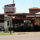
I had been following a blog of the local Big Bend area birds written by employees at Marathon Trailer Park. We talked to Heidi and Matt, set up our new Nemo 3 person tent for the first time and spent a few days around Marathon, specifically the Post Park,at Matt's suggestion, before heading on to Big Bend. We entered at Panther Junction, Dan on bike and me with car, trailer and the five gallon container filled with ice. We carried lots of water, and some food.

Our eyes simply popped out of our heads at the canyon scenery along the way and, sooo different from New England. Soon we arrived at Rio Grande Village, selected our campsite from many, ours had a concrete pad with roof over a solid picnic table, and a soft spot under Cottonwood trees for a tent. We were home for the next few days.

Near the campsite was a five foot by three foot deep metal box with front opening doors, our first introduction to "the bear box", designed to keep food and gear from attracting unwanted visits from hungry bears, and another animal new to us, the Javelina. The Javelina, or peccary, looks like a wild pig, has tusks and dainty, little feet but can be a worse nuisance than a bear. Lots more birds and animals came onto the list, like the Golden-fronted Woodpecker that landed in my still warm from eggs frying pan, Roadrunners, huge Jack rabbits, cottontails, deer and coyote.

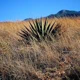
Daily we rode the paved roads exploring on the bike but we used the car a bit, too. Big Bend has many marked and maintained 4X4 roads that we could explore. We bumped a loong 4 wheel drive to Pipe Springs, learning what our car could do,(or not do with its ground clearance) and had a few special days of zooming around on the BMW staying on the pavement as it was pretty dusty, not to mention windy. We never did track down the Colima Warbler there in the park.

One evening and night at the campsite the wind came up suddenly and became very frightening to us as it swirled every which way, kicking up dirt and throwing branches at our little tent home. We couldn't cook and that night we stayed in the car trying to sleep as the noise of the wind rose and fell, thinking about the large branches of the Cottonwood OVER our tent. In the morning the park service had small bulldozers removing debris from the camp!

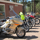
In a few days and after a wonderful, twisty ride to Santa Elena Canyon on the bike, we picked up the tent and gear and headed toward another part of Big Bend, the Chisos Basin Campground. We we fortunate to meet two other couples riding BMW's and had a few fun evenings sharing stories and places to "not miss." Dan and I admired the other folks ability to have all their needs on their bikes. (By that time we had learned that ALL the parks have running water available at what they designate as 'developed' campsites (like where we camped.) Developed sites also usually have flush or pit toilets-no showers but in Big Bend showers were available at the General Store for a small fee. The General Stores in Big Bend are concessions and sell many camping necessities, blankets, tents, pegs. They also stock water, ice, beer, wine and limited food supplies.)

Here are pics from Big Bend. Enjoy the slide show. It might take a bit to load the 80 pictures.

Texas 4 BIG BEND-Guadelupe CarlsbadCavern


After Big Bend we planned a route towards Arizona by way of Davis Mts, where we actually saw the destruction and blackening caused by the recent fire there. The wildfire had burned more than 300,000 acres and threatened the McDonald Observatory which reopened by the time we arrived, so we were treated to a night of exploring the Texas skys on their smaller telescopes. The larger telescopes had been removed for their safety and were not available to the public yet.

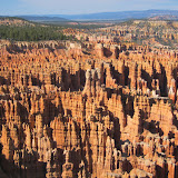
To our surprise we met the same couple riding a Beemer whom we had seen at Big Bend at a campsite in the Guadalupe Mountains. The next day we decided to take a day motorcycle trip with them to NEW MEXICO and the Carlsbad Canyons, only about 40 miles. The day was great, a litttle windy, but the Caverns were magical. We walked over a mile and a half into the mountain on concrete walkways. Then, we were expected to take the elevator out because of the time we entered. Well, OK!


ARIZONA Mid May 2011- next log section.

There are dots on the map in the Western states to illustrate the route of our trip.  To access the correct spot on the map, use the left and arrow up or down buttons to find the orange dots.