(UTAH -Bryce Canyon National Park, rt 12 to Capital Reef National Park, rt. 95 to Natural Bridges National Monument, Valley of the Gods)
BRYCE CANYON NATIONAL PARK
After our few days of rest in Kanab, I just mean on a bed, we're all packed up and riding/driving rt.89 north to Bryce Canyon National park. Along the way we saw quite a bit of flooding in the sreams and creeks along the highway as we made for higher ground. Arriving early in the day we traveled past Red Canyon, and on to t Bryce Campground, which, even in the early afternoon was filling fast. We set up camp, made a fire and enjoyed the cool evening talking with a fellow camper.
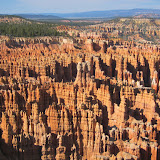
The next day was spent riding the bike to explore the overlooksand do a little shopping at the concession camp store the Parks may have. We bought more of our favorite camp food. Made and packaged in Oregon, Mountain House brand dried dinners, yummy-kinda. The following day we hiked into the canyon to see, up close, the strange formations that eroded a special way in Bryce and vicinity and are named Hoodoos.
Geologically speaking from Ask.com: Hoodoo
"The big geologic dictionary says that only a tall formation should be called a hoodoo; any other shape—a camel, say—is called a hoodoo rock. The defining feature of either one of these is that its shape is bizarre or fantastic. And a proper hoodoo (the word is the same as voodoo), it seems, must look like an image of the spirits that populate the voodoo cosmology—that is, it needs to be spooky. That's a curious eruption of folklore in a scientific glossary, and just another reason to love geology."
Our long walk and hike back out was a highlight and well worth the hours of effort. We started from an overlook point called Sunrise, entered the Queens Garden and regained the rim at Sunset Point. The parks often offer Ranger led or self led excursions. We opted to self-guide and take our time walking at our pace. Since I stop frequently for pictures, that allows a relaxed approach. Still, tourists were everywhere. I especially noted, as we passed them on the hike up, some Chinese? tourists who were just not dressed appropriately; fancy nylon dresses but especially the womens' high-soled flip-flop type shiny gold or sequined platform shoes!
They were warned by the Ranger but they made the climb anyway.
Leaving the park after the walk and a coin-operated shower we made a nightime stop somewhere, but in a nice hotel, and moved on in the morning to see Capital Reef, the next Natioal Park on our treck east and then north heading towards Moab.
CAPITAL REEF NATIONAL PARK
The Native American name for Capitol Reef, the "Sleeping Rainbow," seems to me more picturesque than the name Capitol Reef National Park, which takes its name from a segment of the Waterpocket Fold, a geologic form, with many domes of white Navajo sandstone over red Wingate sandstone cliffs, infused with purples and hints of blue and yellow and white that apparently resembled the domes of the U.S. and other capitol buildings to the namers.
This one hundred mile length of north-south upthrust ridge of slickrock called the Waterpocket Fold reaches from Thousand Lake Mountain to Lake Powell. The area of the National Park that can be explored by paved road is probably about 20 miles. There are some graveled roads leading farther into the canyons now being built, so there was some construction. We drove through I think on a Sunday, so we avoided the construction. Like every day in Texas, Arizona and Utah so far- no rain and warm in the daytime. Nights however can be cool and they were in May-June.
Before the fourteenth century, I read, the now Fremont River area was occupied by prehistoric people known as the Fremont Indians, who scratched petroglyphs and painted pictographs on rock walls near trails and waterways. In 1878 Franklin D. Richards, a Mormon settler, established Fruita ,an orchard where park headquarters is now located. Visitors can explore the farmhouse, a museum and see the non-producing older orchard areas. The feel of Capital Reef was friendly with a large picnic and play area provided for family usage in the park. There was a bit of road construction apparently going on but not on Sunday.
We left Capital Reef behind, its campground was full, not knowing how far we could get to or where we could camp. Only a few towns were listed on our map and the road actually was quite deserted away from the park, but scenic. We pulled into a Bureau of Land Management campsite, and although it was a nice site, it was close to the road and we didn't feel comfortable there, so we moved on. The landscape changed to what I can only describe as the same cliffs and canyons that we'd seen other places in Utah, but now they were all shades of grey and certainly formidable looking- knd of like pictures of a lunar landscape.
We headed into the town of Hanksville toward evening and pulled both of our vehicles into a Rodeway Motel. There were no other vehicles there, but when I spoke with the manager she said they were "all full." She went on to explain that once a year, and this was the time, the town hosts a Robot festival where teams arrive from major Universities around the country; MIT was there and other technical colleges, to have robot competitions out in the desert! In the middle of nowhere is a good description.
Anyway that one motel was full and so was another closer in to the -three buildings and a gas station town- but there was a private campground mostly filled with RVs and trailers. They had tent space and bonus, a nice restaurant, and although we would have loved to see what was going on in the desert, it was not an open event and the few people we talked to just ignored the whole thing. Later the teams returned from the desert to the restaurant and we heard noise until 3:00AM.
EASTWARD to Natural Bridges National Monument
We headed off in the morning after breakfast at the restaurant, east on rt. 24 to rt. 95 and about 60 scenic miles later arrived at our Natural Bridges National Monument. Natural Bridges is an area of canyons and mesas where, due to the raging rivers, fabulous formations have developed over time by running water through the sandstone. In Natural Bridges, we learned that bridge formation and arch formation are similar but there are many more arches formed. Bridges are formed over water and arches can be formed anywhere water has been.
Bridges National Monument is famous for three named bridges a visitor can view from overlooks or they may hike to examine them, taking care not to hike into canyons in the Spring when the snow is melting quickly from the high mountains so flash floods are likely.
The three naturally formed bridges viewed off the paved 8 mile loop road are the Sipapu Bridge, Kachina Bridge and the one we hiked a mile to see, Owachomo Bridge- meaning rock pile. In a restaurant not far from the Monument there is a picture I tried to find a copy of on-line ; a group of mounted cowboys; men whose names were famous in the area as well as government troops posing on the Owachomo Bridge. There were as many as fifty people on the span in the picture. Today no one is allowed on the bridge for safety reasons and to prevent damage.
Here are some pictures of the Bryce Canyon, Capital Reef and Natural Bridges with some driving scenery before and in between.
Dont forget to explore the photos with zoom.
 |
| 8 Bryce , rt 12, Natural Bridges Monument, Mexican Hat |
VALLEY OF THE GODS- MEXICAN HAT
Mexican Hat is a town and a motorcycle ride we were told about by another biker from New Mexico. We visited the area using the car in a quick one day visit. The maps showed construction on the road over the mountain and a dirt road to explore Valley of the Gods- which sounded like a wonderful place to visit. Leaving our camp at Natural Bridges we traveled down, around and around the mountain on rt. 261. At the botton of the canyon was the seven mile gravel road called Valley of the Gods. It is said to remind people who have visited both, of Monumant Valley where Dan and I did not visit. We marveled at the fabulous formations, monuments if you will, we could explore for all sides from the dirt road. Even the road was fun to drive because of steep rises and plunging falls as we passed some of the formations, old washes, dried creek beds. After a few hours of exploration on the 7 mile road, we continued on to the town of Mexican Hat. The rock formation definately showed us we were near the town of under 100 inhabitants. We drove in to the one gas station, saw tourists ready to ride/float the San Juan River, ate at a small local cafe and discovered the Polygamy Porter brand of beer; low on alchohol at 4.5% alcohol content but fun to read the label! (Remember the Pipe Springs hiding of the extra wives at the fort)
Dan and I were literally blown away when we exited the cafe and headed, head down to avoid the dust and wind, to our car. Soon we arrived at the entrance road to Gooseneck State Park and the meandering San Juan River, spent a very short time there and headed back to 261 and Natural Bridges. When we arrived there was still lots of wind at the campsite. We noticed we had more than a bit of fine, red sand in our tent, covering sleeping bags and stuck in the mesh of our tent! We cleaned it up but the wind still blew all night and we needed to clean up again in the morning, as well as refill our water bottles three miles down hill at the visitors' center and off we headed east to rt. 191 and the town of Monticello, Utah.
STILL IN UTAH and headed South next.


No comments:
Post a Comment