Monday, October 31, 2011

Catch up - September 2011

SEPTEMBER and OCTOBER 2011

One day in early September Patty and Gary and young Donovan took Dan and I surf fishing at the National Seashore.  Driving along in the car we saw this three foot rattler crossing the road. I just had to get a picture.  It was so beautiful.


Safety of the roadside bushes.

Donovan loved the beach.

Gary got the gear and set up his surf poles with shrimp bait

Had to put the poles together first


Soon after this picture out came the chairs and beach umbrellas, but keeping up with rebaiting the lines took some focus and energy.  We were rewarded by three whitings(fish)
During this time sometime Patty and Gary, Dianne and Jim and Dan and I went clamming which required actually moving our boats from the slips and a five mile trip.  It was my first time trying to catch, dig, clams.  We did it with no equipment except hands and feet.  Feet wiggle and dig in the shallow, muddy bottom of a patch found by one of the other four native experts.  Once a likely shell is "felt" by toes, the toes dig a bit and then we pick up the clam with a hand, if possible, or a two foot squeeze and lift if the water is too deep.  We were able to find lots; a few hundred of varying sizes- which made steamers, stuffed oven-baked, and chowder extradinaire!

THEN..

Now it is October 9th and we have prepared the boat as well as we could for the storm working her way along the Florida coast that hadn't been officially named.  Thus The No-Name Storm. We received rain and lots of wind.  Before the storm really developed we went exploring.

Nice day to check out the conditions at the National Seashore and Merritt Wildlife Refuge

Then along came the “no name” storm October 9-11.  Lesser developed storms, (lower wind forecast and less clear development of a central, swirling mass called the eye) do not receive names from the weather service.  They are not expected to develop tropical storm characteristics.  Well, “no name” perhaps should have had a name as it dumped lots of rain on already soaked areas, bringing down trees and wires and the wind along the Central Florida Coast reached hurricane force with 64mph measured at the Haulover Canal Bridge only four miles from our marina-- and 81mph measured out at the beach on Merritt Island!  For us it meant an afternoon, night and morning of sustained high winds before the storm moved away.

  As the pictures below show, Titusville sustained first 20-25knot winds for hours --then they grew until we had hours of 40-45kn winds.  Watch the difference between the mph measurement and knots.   We had “Near Gale to Strong Gale.” on the scale used to describe storms at sea.

  Wind whistles through rigging in our sailboat, into the boat through dorades, (funnel like protrusions that keep the air circulating through the boat) and depending on the direction, our firmly tied boats heel at the dock.  With the movement, the fenders, (ball-like rubber inflated to provide protection from the dock)squeek while the dock itself groans. It keeps your mind on the weather outside.

While sitting watching the electronics for a reading on the wind for hours, without being able to use our TVs or computers (electricity is off, cable lines down), we were able, to listen to marine stations on the VHF or Single Sideband radios.  There was at least one boat from the nearby anchorage that dragged and was destroyed. The boat dragged due to wind and the direction of the wind pushed the 40 ft.sailboat right in through the marina opening until it crashed and sunk at the nearest Tee Head!  Luckily one large motorboat saw what was coming and moved before the run-away struck him.  

On the fixed docks at the marina, things were quite wild during the “no name” storm,  with unattended boats perhaps hitting or bouncing high enough to hit the docks as the water surged and larger waves came in.  The fixed (wooden unmovable)docks are new and built between strong concrete and wood pilings, so the bouncing boats receive the damage because there is no “give” to the dock.  On E dock we just waited out the wind with a lot more protection and were thankful for our floating concrete docks.


                                   Out exploring before the main storm hit.


By now it was raining quite hard and sand was blowing. It was not comfortable to be out. 

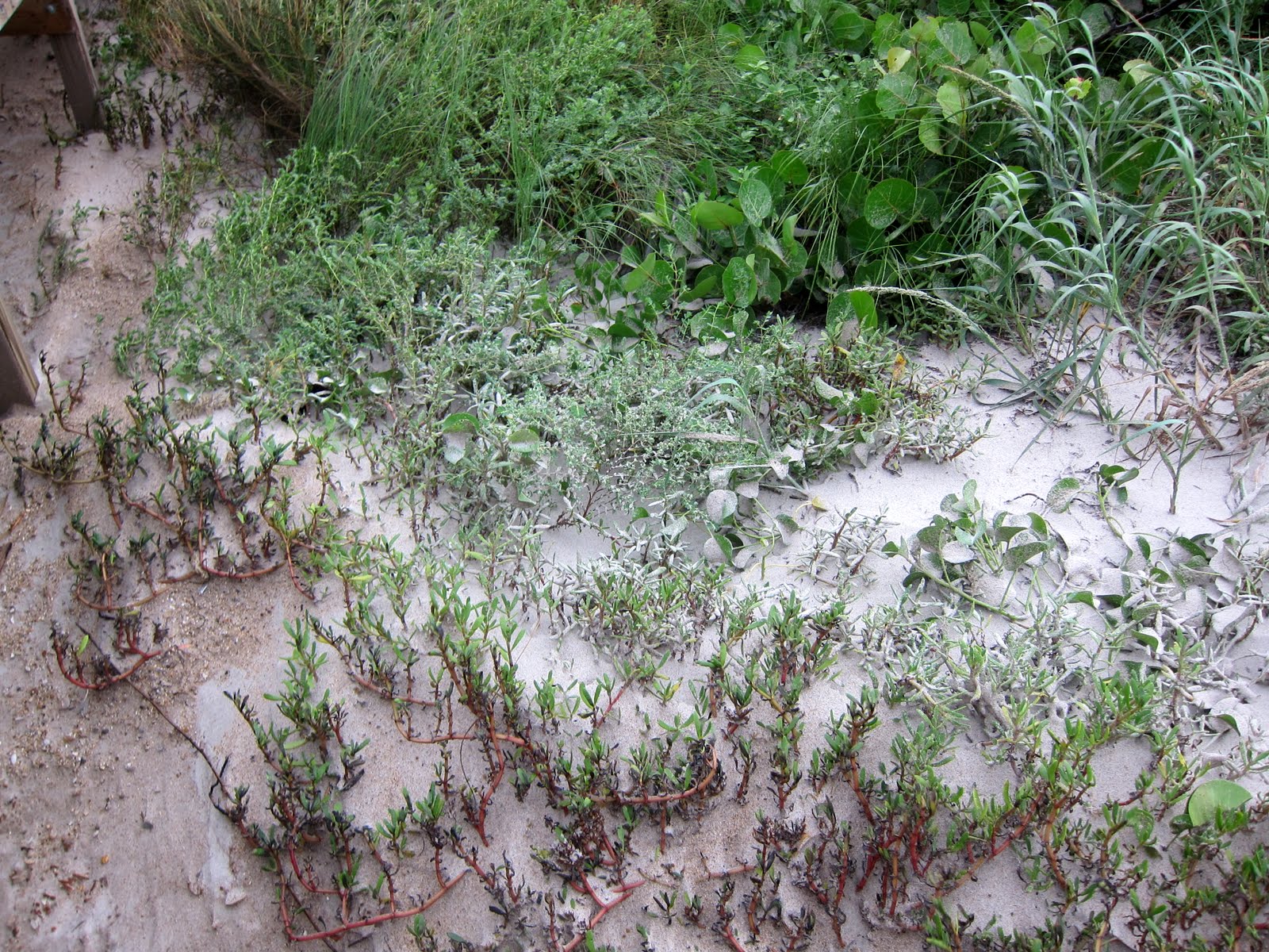
Sand covering the plants


A little windy.

But later the birds came out....

As did this large gator!


Heron

Wood Stork

It's always good to look for shelter on a bad day. This is a restaurant over the Merritt Causeway where we stopped  on the way back to the marina 

Back on the boat it was quite windy..

for a pretty long 5 or 6 hours or more

Eventually we could all emerge onto the dock... These girls belong to one of the boats...

This is Puss, the neighbors cat.  Who does she remind you of?

Here some folks were decorated for Halloween

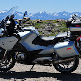
Later in October we got some of our stowed gear out of storage and took a weekend trip to Key West with a fellow BMW rider, Martin.

We saw Key Deer where we camped.


This restaurant has dollar bills stapled to all the walls.  I think there were over 10,000 individual bills stapled there.


We rode all the way down to Key West


Famous Duval St.


This is a sculpture to honor fishermen.
And then it was Halloween.  Samantha, as Willy Wonka (scarf) from the boat next to us.

See you again in November!


Sunday, October 9, 2011

"THE GREEN TABLE " MESA VERDE NATIONAL PARK July 27-31, 2011


Mesa Verde
The Green Table.  Mesa Verde National Park, COLORADO.


“On a snowy December day in 1888, while ranchers Richard Wetherill and Charlie Mason searched Mesa Verde’s canyons for stray cattle, they unexpectedly came upon Cliff Palace for the first time. The following year, the Wetherill brothers and Mason explored an additional 182 cliff dwellings.”

“ June 29, 1906, President Theodore Roosevelt established Mesa Verde National Park to "preserve the works of man," the first national park of its kind. Today, the continued preservation of both cultural and natural resources is the focus of the park's research and resource management staff.”

Mesa Verde preserves the artifacts and homesites of early Indian settlers, the Ancestral Pueblans, formerly referred to as Anastasi People, and others who came after.  These people lived and farmed the high mesas (therefore the name Green Table) of the four corner region of what is now Colorado, Utah, New Mexico and Arizona.  Three groups are represented there; the very earliest people were called the Basket Weavers but they were not the builders of the cliff dwellings.  The following NPS website explains the history.  
(if you choose to check the link, you will navigate from this blog-I don't know how to insert the site and bring you back to blog without reloading) 


National Park Service - Mesa Verde

Puebloans and their world

 They left behind the interesting sandstone brick homes, bricks made one at a time and buildings to as tall as three stories in height, and more questions than the scientists or Park Rangers can answer.  Through ongoing research by archeologists and scientists, Rangers try to dispel myths- one of which concerns the difficulty of Ancestral Pueblan lives and in the same vein, the need for protection from other marauding tribes.  While walking the cliff house dwellings with a Ranger we are told these were probably non-warlike people; farmers who despite the lack of steady sources of water and too hot or too cold climate, coped well with their environment.  Due to archeological finds of decorated basketry and sophisticated pottery, it is assumed they had access to trade and leisure time.  

Our visit included climbs and long walks to three major Cliff Dwellings in the park, Balcony House, Cliff House and Long House- fabulous ruins and examples of the larger dwellings built, some with over 150 rooms. The Rangers say the houses are not reconstructed in any way but “stabilized” by a few metal beams and monitored.  As the homes fall, and they do, the old beams are saved and the hand- made bricks piled and saved.

In Mesa Verde there is a comprehensive museum to assist the visitor in understanding what can be ascertained about people who lived so long ago.  Beside the artifacts; tools, clothing (surmised from current practices of today’s Indians), in 1930 during the Civilian Conservation Corps  maintenance in the park, artists completed large dioramas to demonstrate what the lives of the three groups of early  peoples’ might have been like.  Dan and I found the museum information; explanatory movie, the exhibits of brick making, use of naturally occurring grasses and foods to enhance the enjoyment of the park.

There are two paved roads throughout the park that allow visitors to access the hikes and visit exhibits. After a day on the east side of the park, Balcony House, Cliff House and views, we camped in the park and decided to see the Long View House.  Few tourists visit the western part of the park where Long House is located, so we decided that was the place we should ride to.  The road would climb up to the top of the mesa in a series of hairpin switchbacks, so it would be fun if there were little traffic. Unfortunately, when we arrived at the locked gate to Wetherill Rd. rather early there were already some cars in line. We kinda worked our way forward so Dan could immediately follow the Rangers as they drove up to the site of Long House.  Actually, Dan wheeled to the front of the line of visitors, then slipped in line behind the woman Ranger who was driving.  Whahoo!  She proceeded to wind her way up the mountain at a perfect speed for us to wind up at a reasonable speed behind her, both of us leaving the waiting cars and pickups behind.

When the others arrived we all rode a shuttle bus for a short trip to the path to Long House and we hiked behind the Ranger down the winding paved path to the cave dwelling; Long View House.  He told us about the use of yucca for shoes, and basketry and that a yucca fiber rope of 900 ft. length had been found at LVH.  He pointed out the row of finger and toe holds the cave dwellers used or chipped, along with yucca rope ladders, to enter or leave their homes to the mesa high above.  Under the ledge of the cliff overhang above the housing structure was built a grainery room for storing the corn, squash or beans grown for food.  The Ranger suggested that much is known about the daily life of the people because they basically threw the refuse over the edge of their cliff, including the dead.

We looked into one of the many Kivas, a round hollowed area in the lower level probably used for ceremony as well as daily life.  The Kiva fire is central to the circle.  In front of the fire, oriented south is a vent column open to the top, a vent outlet is at the base and a deflecting stone helps keep the entering fresh air circulating around the circle.  The entry would have been by ladder through a hole in the wooden beam circular ceiling, through the hide-coated roof structure, directly over the fire circle. 

The archeologists over time have discovered more about the materials used and that these people fired beautifully decorated functional pottery, made arrowheads and stone tools and fashioned decorative items like beadwork and jewelry.  From these items they’ve surmised that the people of the cliff dwellings had leisure time and did not engage in warfare.  As the Ranger said, “The people did not ‘vanish’.  People do not just vanish, they may have moved farther south to what is now New Mexico as there are 22 Indian tribes along the River.


Returning after our tour, a walk and birding on the Wetherill west road, we were coasting our way back down the mountain when we saw right in front of our eyes, possible disaster.  We saw a very young black bear- ON OUR SIDE of the road!  We heard each other gasp but it was too “late” to stop or to change course.  Dan slowed as much as he could but I just held on to the bike and focused on the cute little animal just standing there.  It looked like we could pass it; then it started across the road right in front of us.  Dan swerved then sped up to straighten out- (luckily there were no ascending cars at the moment) and we missed that cub by inches! I could have touched his little furry back- ‘cause I wasn’t driving.  Around the next bend Dan pulled over to breathe.  He had seen the Mama bear close to road in the bushes on the side the cub crossed safely to.  That was a close call, I guess for all of us -except Mama Bear, who might not have been in a good mood had we run over her cub….. and maybe dropped the bike!
See my 3 internet chosen -copied pictures to illustrate.


bear black


Anyway, all was well and we had quite a story for our last real day of the west trip that had started mid April.  It was now July 31, 2011 and we were hearing of bad weather heading toward Florida.  After visiting Mesa Verde, one of our personally favorite National Parks, Dan and I strapped the bike on the trailer and headed for Florida.  Thanks to the kindness of the cruisers on our dock at Titusville all was well with Sea Star when we returned three days later.  We arrived in time to hear that Tropical Storm Emily had not developed further and then was disintegrating before troubling Florida.   


Editorial comment from Kathy:  


The Parks are way beyond “beautiful” and, in my opinion, areas for the young to hike and explore are essential to coming generations understanding of the American Experience.  The resources, the geology, biology; plants, birds and animals were noted as essential by forward thinking scientifically-minded citizens, as well as Native Americans who encouraged their preservation.  Some Presidents have been more convinced of the importance of natural lands than others.  My hope is that the fight to preserve and protect will not succumb to desire for the riches.


Enjoy my last slideshow from our “Go West”, _____Man and Woman” scratching the surface of some National Parks in the USA and Canada.  


Mesa Verde


This is Mesa Verde, Colorado - we camped here.

View Sea Star Trip Path in a larger map

Friday, October 7, 2011

ROCKY MOUNTAIN RIDING ROUTE July 25-28, 2011

Leaving the Tetons and Gros Ventre, in Wyoming  we had another long ride, with some desired stops, on our way to Mesa Verde National Park in southwestern Colorado.  The route we took retraced our steps to 287E through Arapaho Indian controlled area along the Wind River, and toward Lander, stayed overnight at the Maverick Motel, drove over the historic Overland Stage Route of the Oregon Trail and the town of Rawlins. Along the highway were beautiful painted cliffs similar to the dessert.  We stayed in Lincoln campground in Medicine Bow at the end of a long day.  


The next leg of 130 mountain miles, brought us to route 130 and over the Snowy Range Pass at 10,847 feet and Medicine Bow Mt., even taller, until we crossed the border into Colorado at Tie Siding.


Poudre Canyon and Poudre River, where we took a campsite at Kelly, were along the next section on route 14 then west to the Arapaho Wildlife Preserve.  The Preserve route, 125 then 40, 70 and 91.  Route 91 runs close to the scenic road, 24, described below.  I could see the 14,000s as we continued on the highway that ran over and through heights of 6000' to 8000'.  I love my Subaru, but it struggled even with the trailer empty!  Dan, of course, had a much easier time driving the mountains.  He was cold, but the bike was the way to go- only he had to slow considerably to allow me to keep up as we hadn't discussed the route. Leadville was the place we found a hotel and planned the rest of the trip. 


Information on the 14,000s Scenic route 24 is from internet research.  We rode rt. 91 but it was from north to south.  The description below is from south to north.  There is no doubt the mountains are amazing.  It's fun to see their Collegiate names now.  At the time we rode through they were just "the Rockies".


  "One of the scenic drives in the Rockies is a section of US 24 called the Highway of the Fourteeners, because it passes a total of ten 14,000 foot peaks on either side of Buena Vista.  There is no other stretch of highway in the U.S. where you will see this many of the highest peaks together nor be able to view them so closely.  The pointed summit of Mt. Princeton first appears, later you have the first full view of Mt. Princeton, a massive mountain with great shoulder peaks on each side of the summit. Following Princeton in succession to the right are Mts. Yale and Columbia.  You then sight the sharp peak of Mt. Harvard (3rd highest peak in the Rockies), and to its right Mts. Missouri, Belford, and Oxford, all higher than 14,000 feet.  US 24 goes through the town of Buena Vista and for another 3 miles north of town, the road passes 3 or 4 miles from the Fourteeners and you have a close up view.  After Mt. Yale look for the beautiful view up North Cottonwood Basin to the Continental Divide, with the pointed Birthday Peak at the far end, standing on the Divide about 10 miles away."


As Dan and I emerged from the mountain and our view of Mt. Princeton, we turned west and were on a much less traveled road on our way to "The Million Dollar Highway", another famous biking highway and on our way past Durango, CO toward Mesa Verde. 


Quotes mostly from Wikipedia
"The original portion of the Million Dollar Highway was a toll road built by Otto Mears in 1883 to connect Ouray and Ironton. Another toll road was built over Red Mountain Pass from Ironton to Silverton. In the late 1880's Otto Mears turned to building railroads and built the Silverton Railroad north from Silverton over Red Mountain Pass to reach the lucrative mining districts around Red Mountain, terminating at Albany just eight miles south of Ouray. The remaining eight miles were considered too difficult and steep for a railroad. At one point a cog railroad was proposed, but it never made it beyond the planning stage.
In the early 1920's, the original toll road was rebuilt at considerable cost and became the present day US 550. The Million Dollar Highway was completed in 1924. Today the entire route is part of the San Juan Skyway Scenic Byway. "

"The Million Dollar Highway stretches for about 25 miles in western Colorado and follows the route of U.S. 550 between Silverton and Ouray, Colorado. It is part of the San Juan Skyway Scenic Byway. Between Durango and Silverton the Skyway loosely parallels the Durango and Silverton Narrow Gauge Railroad." 


Looking south toward Red Mountain Pass.
This section of the route passes over three mountain passes:
Coal Bank Pass, elevation 10,640 ft 
Molas Pass, elevation 10,970 ft  
Red Mountain Pass, elevation 11,018 ft


The origin of the name Million Dollar Highway is disputed. There are several legends, though, including that it cost a million dollars a mile to build in the 1920s, and that its fill dirt contains a million dollars in gold ore.

and from Wikipedia a really good description:
"U.S. Route 550 though the entire stretch has been called the Million Dollar Highway, but it is really the twelve miles south of Ouray through the Uncompahgre Gorge to the summit of Red Mountain Pass which gains the highway its name. This stretch through the gorge is challenging and potentially hazardous to drive; it is characterized by steep cliffs, narrow lanes, and a lack of guardrails; the ascent of Red Mountain Pass is marked with a number of hairpin "S" curves used to gain elevation, and again, narrow lanes for traffic—many cut directly into the sides of mountains. During this ascent, the remains of the Idarado Mine are visible.  Travel south from Ouray to Silverton perches drivers on the vertiginous outside edge of the highway. Large RVs travel in both directions, which adds a degree of excitement (or danger) to people in cars. The road is kept open year-round. Summer temperatures can range from 70-90 degree highs at the ends of the highway to 50-70 degrees in the mountain passes. The snow season starts in October, and snow will often close the road in winter."


Enjoy the slideshow of as many pictures as we have of this terrific riding area; great scenery and lots of thrills.  Nice country.


Poudre to Molas, Red MT 20


Wednesday, October 5, 2011

THE BEARTOOTH, YELLOWSTONE and GRAND TETONS July 20-24, 2011

MONTANA to Wyoming Yellowstone National Park, Grand Tetons.  July 20-26, 2011


Moving on to Yellowstone National Park 


Eureka, Montana was a day drive away from our next target.  Beartooth Highway at the border of Montana and Wyoming. We had to travel from NW Montana to SE Montana and enter Wyoming.  Dan was a bit fatigued from the week of daily 2 up riding in Canada and decided to rest for two days by using the trailer for the bike until we were closer to Beartooth Highway.


We began to repack everything into the car and after food shopping and clothes washing and sorting, packing and sleep we returned the bike to the trailer and set off.  Using the major highways we headed south, then east on rt. 90 to 212- the Beartooth! 


There was a lot of motorcycle road to cover on the way from Glacier to Yellowstone.  Dan had met various bikers along the way who said “ Don’t miss the Million Dollar Rd,” or “If you go into Yellowstone from the East, you should first find the Beartooth Highway.  You ride through the Absaroka Wilderness area in Targhee Forest. Best road I ever rode on!”


A full day was necessary to cross Montana and the next night the town of Red Lodge was as far as we would travel. So after dinner in Red Lodge we looked for a place to stay and found a Forest Service campground.  As we set up the tent the wind was howling and there had been rain while we ate Mexican food at Red Lodge.  The creek we had to pass over to arrive at the campsite was raging as were most of the Montana mountain creeks we passed. Snow cover in the Rockies was said to be higher than normal, with temperatures colder recently, so as the sun and temperatures were increasing, so were the creeks rising.  Next morning after breakfast we kept on Beartooth for the 69 mile trip.


BEARTOOTH HIGHWAY


Wikopedia says, "The Beartooth Highway has been called "the most beautiful drive in America," by late CBS correspondent Charles Kuralt.[1] Because of heavy snowfall at the top, The pass is usually open each year only from mid May through mid October because of heavy snowfall at the top, weather conditions permitting.[2]

The Beartooth Highway is the section of U.S. Highway 212 between Red Lodge, Montana and Cooke City, Montana. It traces a series of steep zigzags and switchbacks, along the Montana-Wyoming border to the 10,947 ft  high Beartooth Pass. The approximate elevation rise is from 5,200 ft  in 12 mi  in the most daring landscapes.
When driving from the east to the west, the highest parts of the Beartooth Highway level off into a wide plateau near the top of the pass, and then descend to where the Beartooth Highway connects to the Chief Joseph Scenic Byway near Cooke City, which forms the northeast gateway to Yellowstone National Park. En route, one passes numerous lakes typical of the Absaroka-Beartooth Wilderness Area which borders the highway along much of its route.
The highway officially opened June 14, 1936.
Because of the high altitudes, snowstorms can occur even in the middle of the summer and the pass is also known for strong winds and severe thunderstorms. Plan on a driving time of at least two hours for the 69-mile long trip from Red Lodge to Cooke City. 
The Beartooth Highway passes through portions of Custer National Forest, and Shoshone National Forest and near the Absaroka-Beartooth Wilderness."

Dan agreed with Charles Kuralt and other riders who either told us not to miss this road or whom we met enjoying the view along the road.  It was certainly one of his favorites. Our day was sunny and dry, but a bit windy.  The mountains were high, but the road was well kept and traffic not a big issue.  


Yellowstone National Park


Our lunch stop in Cooke City finished, we grabbed some ice, a few groceries, and entered Yellowstone National Park from the NE.  After the winding driving concentration required during the morning on Beartooth Highway, Dan was pretty tired but we had to drive miles late in the day to find a campsite.  There aren’t too many choices for camping near the entrance we used.  We drove by the three campgrounds and they all had signs “Full.”
 It was now summer and Yellowstone is the National Park with highest visitation.


In tired frustration we spoke to a Ranger who had just left work at the Ranger station.  Somehow he felt sorry for us when I related the “campground full” story and he suggested that because Dan was on a bike, we could try the hiker/biker section of the Tower Falls campsite, a special section reserved for hikers or bikers since they have fewer options than car campers.  We did go to look, and low and behold there was one unoccupied spot and enough room to park.  This was much better than driving out of the park and re-entering in the morning, at least 25 miles one way which was our next option!


It turned out to be a great spot!  Dan and I went for a little walk, binoculars in hand, and were able to see three Mule deer, one a large male, and, rustling in the bushes near us we looked down and saw…a black bear.  It very slowly ambled away from us, but I backed away from it back up the hill.  Dan kept watching it.


That evening we talked for a long while around the campfire with a young man who was bicycling the Beartooth the next morning.  He was telling us the places he had biked; some of the mountains we had ridden, but with two strong motors.  He was in very good shape, obviously, but bicycling the Beartooth?  Since he left early and was going the opposite way, we wondered after how he had done! 


In the morning we lurked until a nearby camping family left, grabbed and paid for the now vacant site for a night, so we could go out and explore the park and have a place to come back to.  We left the car and set off down the rough campground road to the main loop heading west.

Yellowstone has miles of paved road to explore, the road makes a large loop around the park and off toward the various park entries, meaning to go the entire way around would be many miles on the bike.  We headed to Mammoth Hot Springs at the North Entrance and would continue around toward Old Faithful, unless we didn’t get there. There were many turn-offs and vista to stop and explore.

 Unlike many of the National Parks we visited where we did not have the roads to ourselves, but…the traffic wasn’t too bad, EVERYBODY wants to be in Yellowstone, making the traffic abominable.  RV’s, trailers of all sizes, a gazillion cars, pickups, 4X4’s and even other motorcycles clog the turn-offs, crowd the roads and parking lots as they crane their necks to spot the prolific wildlife, especially the Grizzly bear or Elk then they/we steer off the road in unapproved places, cameras, scopes and binoculars in hand.  Bison and Black bear can be seen sometimes, too.

Leaving the campground we bought breakfast at the historic landmark Roosevelt Lodge and Horse Stables, viewing meadows of tall grasses stretching to the base of low mountains and, at Indian Camp, Alpine meadows containing small ponds, each pond with its own fly fisherman. The groups and couples enjoying these lessor peopled places appeared tranquil  because people were taking time to walk and engage with the surroundings in a different way than the more frantic auto traffic.


 I knew Yellowstone was famous for Old Faithful Geyser but there are a lot more than the one geyser in the park. Yellowstone SW road has many places where the ground spews steam over a crusty ground.   We found the “hot and steamy” side of the park very interesting with its plumes of steam and incredible pastel rainbow colors.  There was even a bubbling caldron of white mud with bubbles bursting six inches above the ground level called the Paint Pot.   Geothermal anyone?

The day was hot, the ground was hot, and the motorcycle was hot especially wearing all the gear, so we headed back to camp for the day arriving late in the afternoon, and not reaching Old Faithful.  The following day we started around the loop the opposite way, up the mountain to Dunraven Pass at 8900ft.  There were some RV’s on this twisty, steep mountain road.  They couldn’t climb the mountain and held up traffic. Passing, even on the bike, was difficult.  We headed now south to Canyon Village, Lake Village, Yellowstone Lake, a beautiful thirty mile glacier lake where apparently many types of Salmon and other fish live and the local people and tourists fish with local guides.  In some places hunting is allowed in the park, too.  There were just as many places to stop and explore or walk –we never made Old Faithful—but that’s OK as we thought we may have to stand around for a long time, as long as 90 minutes, to see an eruption.

We left the Park by the South Entrance and headed for Grand Teton National Park, just 60 miles away, much less traveled and another park filled with fabulous sights; snow covered high mountains and lots of buffalo.  At the end of two days in Grand Teton we left the park and camped at Gros Venture which involved a twenty mile gravel and dirt road for Dan and a rattletrap jarring for the trailer and me in the car.


Dan and I were off to western Colorado and our to be last stop; Mesa Verde National Park.


YELLOWSTONE INFORMATION

Established in 1872, Yellowstone National Park is America's first national park. Located in Wyoming, Montana and Idaho, it is home to a large variety of wildlife including grizzly bears, wolves, bison, and elk. Preserved within Yellowstone National Park are Old Faithful and a collection of the world's most extraordinary geysers and hot springs, and the Grand Canyon of the Yellowstone.


Did You Know?

Yellowstone contains approximately one-half of the world’s hydrothermal features. There are over 10,000 hydrothermal features, including over 300 geysers, in the park.
  • An active volcano
  • Approximately 1,000–3,000 earthquakes annually
  • Approximately 10,000 thermal features
  • More than 300 geysers
  • One of the world’s largest calderas, measuring 45 by 30 miles (72 by 48 km)
  • Thousands of petrified trees in northern Yellowstone
  • Approximately 290 waterfalls, 15 ft. or higher, flowing year-round
  • Tallest waterfall: Lower Falls of the Yellowstone River at 308 ft. (94 m)


YELLOWSTONE LAKE
  • 131.7 sq. miles (35,400 hectares) of surface area
  • 141 miles (177 km) of shoreline
  • 20 miles (32 km) north to south
  • 14 miles (23 km) east to west
  • Average depth: 140 feet (43 m)
  • Maximum depth: about 410 feet (122 m)


CULTURAL RESOURCES
  • 26 associated American Indian tribes
  • Approximately 1,600 archeological sites
  • More than 300 ethnographic resources (animals, plants, sites)
  • More than 24 sites, landmarks, and districts on the National Register of Historic Places
  • 1 National Historic Trail
  • More than 900 historic buildings 
  • More than 379,000 cultural objects and natural science specimens 
  • Thousands of books (many rare), manuscripts, periodicals 
  • About 90,000 photographic prints and negatives
LA
Internet Website: www.nps.gov/yell/

http://www.nps.gov/imr/templates/images/graphics/spacer.gif
Yellowstone Wolf.
Did You Know?
There were no wolves in Yellowstone in 1994. The wolves that were reintroduced in 1995 and 1996 thrived and there are now over 300 of their descendants
 living in the Greater Yellowstone Area.


Enjoy our slideshow of  Beartooth Highway, Yellowstone and Teton National Parks


Yellowstone & Grand Teton