Sunday, September 25, 2011

BEAUTIFUL WILD CANADA.July 10-15, 2011


Banff, Jasper, Waterton National Parks
Eureka, Montana  July 10-15, 2011  Invermere on route 93/95 to Banff, Jasper, Lake Louise, Waterton Glacier


 Dan and I were driving along an excellent biking road in Idaho having driven the Cascades Highway rt. 20. when we stopped at Bonner’s Ferry Campground to rest.  It was then that we discussed the possibility of taking only the bike into Canada to Banff National Park, then Jasper National Park for about a week.  As we figured out what we would absolutely need to camp, and bring all our riding gear, we thought the plan was do-able, so we used the picnic table we were sitting at and started to refold our tent, sleeping pads, sleeping bags and other “stuff” to their original small sizes. Yes, we could, with difficulty, get it all to fit including the new, velour blanket I had insisted on buying a few campsites previously.   The next part of the plan was to find a place to leave the car and trailer for the week.  We found such a place, the friendly Motel Ksanka in Eureka, which put us close to the US / Canadian border at Kalispell. 

The border crossing was quick and straightforward; “How long will you be in Canada?  Have you been here before?  US citizens? Show passports." Done.  

So July 11 found us following rte. 93/95 N, a slightly winding, very scenic road we followed to the town of Invermere, the first place we could change money, and then, before I even realized it from my perch on the back, we were in line to enter Banff.  The Ranger asked, "How many days will you be spending in the park?"

After getting over the shock of $20 a day for Park entry, plus $27.00 daily for a campsite and $8.00 extra for a fire ring (wood included), the very most we had spent camping on our trip, (especially since US Parks allow us to enter for free), we zipped into the Banff National Park for at least two days, and immediately began to enjoy the high mountains behind greenstrip scenery and the deer frequently seen along the side of the road. The road signs suggested more wildlife to come; signs for elk and bear and warning signs for drivers to be watchful for wildlife came into view. 

Our heads swiveling like bobble-head dolls, both watching for critters, as we enjoyed the 
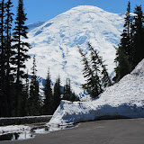
open view from the bike. Banff and Jasper both consist of mountainous terrain with glaciers, icefields, dense coniferous forest and alpine landscapes.  The Icefields Parkway extends from Lake Louise and connects with Jasper National Park in the north.  

Mt. Rundle, seen from the town of Banff and Castle Mountain are a few of the named mountains within the overlooking cambrian cliffs, rising high above our heads.  Our exploration took us past Kootenay Hot Springs, Attrude Creek and to Tunnel Mountain Campsite for our first night in the park, where I read there actually is no tunnel through Tunnel Mountain.  A mining company wanted to put a tunnel there but never did.  

We were close enough to the upscale tourist recreation town of Banff to ride in for a pizza, then return to set up camp and start the fire to keep mosquitoes at bay. We met and shared our pizza with a BMW rider from Maui, thinking it was strange that we met two BMW GS riders on our trip and they are both from Maui!  The second one told us he was only aware of two GS bikes on Maui, his and a silver one.  I wondered if it was Pats'.

Next morning we awoke to cold, probably low 40's, so we stayed in the tent awhile, then drove into Banff town again and sought out breakfast since we had no cooking supplies with us- not even coffee!   Fully geared up against the cold, we followed rt. 1A, the Icefield Highway, all the way to Jasper Park, along the way stopping at intriguing overlook and pull-offs, awed and gasping at the size and then increasing size and isolation of these massive Rocky Mountains, their bases running with icy streams, sometimes gushing torrents, of melting snowfall; a wonderful, smoky-looking new-to-us shade of grayish-aqua. On our previous travels on Sea Star we met astounding hues of blue, and here was a completely new one.


We drove down a dirt road and explored a small part of the Columbia Ice Fields where tourists may walk, or take an ice shuttle to get a better view of the many glaciers.  There were signs showing us the extent of glacial movement in previous years.  We walked with bus loads of other tourists to Athabaska Falls, a spectacular waterfall below the Athabaska Glacier and then headed for a new campground, in the area of Jasper National Park-even less traveled than Banff.  Exhausted from a long day of riding, we went to the closest place we could for dinner, a mile away Jasper Mountain Lodge. Jasper Lodge while quite attractive was, like many of our hotel choices in or near the parks, prohibitively expensive for a room.  Typical tourists we figured might pay $150.00 per night to stay inside, so we were glad we had brought our gear with us.  People camp with RVS or pop-up campers and they made up most of the campers we saw.  We did learn that there are hostels and even some other accommodation choices that serve tourists who bike, hike or climb more cheaply.


In the morning, a late start again as we had to go to Jasper town to eat, we traveled even more carefully because of fog and then pouring rain, back over the mountain passes, this time using route 1 to Banff, then on toward Lake Louise, where we wanted to camp. Along the way, in the rain we met and talked to two kinds of recreational tourists.  The first young woman turned her bike into the pull-off where Dan and I were under a semi-shelter, and joined us.  She was part of a mountain street bike trek, freezing and waiting for a van pick-up to bring her the last 7 miles to Columbia Icefield- an RV was there that she would stay in for the night. The second tourist was a man our age who was also bicycling to the Icefield.  He had an older bike, was dressed in a typical poncho and carried his tent, etc.  He chatted with us a bit and off he went.  That evening he would sleep at a hostel near the Icefield, because of the wet. He did his own planning, used no high tech clothing or technology.  I was impressed, because even on the BMW we were still barely surface covering the parks.  More time, more time is needed.


 When the rain stopped, well, actually it didn’t, we were soaked, but we continued on toward Lake Louise.  After a bit of confusion about where the camping was, we put up our tent and built a fire.  Now was the time to dry our riding clothes and boots over the fire.  Lake Louise town and wild areas were having some problem with  black bears.  It was Spring there and the bears were coming out. To cope with bears that might come in the campground smelling for food, the fence encircling the campground is electrified.  We had no problem and only saw roadside bears as well as elk and black tail deer.

Leaving the Parks we headed for a road on the map that Dan thought “looked interesting” and perhaps it would have limited traffic.  He was correct on both counts. Driving rt 11 then 40 through Kankanasus Wilderness Road allowed some great wildlife sightings and was more fun motorcycling- even given driving cautions to warn drivers that the creatures could easily be running across the road, which we learned we had better heed.  Kankanasus area included fabulously green, stick straight expanse of evergreen trees and aspens. Acres of flowers infused the alpine meadows.  The roadside information podiums tell of the unbelievable age of the stunted trees and meadow vegetation.


After crossing a place named Highwood Pass at about 10,000 ft., where wild mountain goats were grazing, then many more miles of travel,  we found a tiny store where we had a yummy supper of microwaved cheeseburger, and Klondike bars, found a roadside campsite where we were the only campers.  The cotton plants were exploding pollen everywhere and ground squirrels were as plentiful as ants but our spot on the river was very pretty.  

Next morning we headed on towards Waterton. We passed lots of interesting sights.  We tried to visit the Buffalo Preserve as we came back in sight of the Montana Mountains.  It was pretty but, unfortunately, we did not see buffalo. It was strongly suggested that motorcycles not enter the preserve.  I wonder why?

Waterton National Park is the Canadian portion of the combined Waterton Glacier Peace Park.  We camped one night in the Canadian section, then drove the bike back into the US so we could enter Glacier National Park from the east.  We had been without our internet or phone while in Canada and wondered if the Glacier National Park Road to the Sun had yet opened for the season.  If it had not we would have a long drive to return to Eureka, Montana and the car.  We would have to check later, closer to the Park entry.

Some  Canadian Park, information from internet sites or maps we were given.

"The contiguous national parks of Banff, Jasper, Kootenay and Yoho, as well as the Mount Robson, Mount Assiniboine and Hamber provincial parks, studded with mountain peaks, glaciers, lakes, waterfalls, canyons and limestone caves, form a striking mountain landscape.

In the fall of 1883, three Canadian Pacific Railway construction workers stumbled across a cave containing hot springs (these natural hot mineral springs are among the top attractions in the Canadian Rockies. Banff Upper Hot Springs offers a splendid historic bathhouse located in Banff National Park. Radium Hot Springs in BC’s Kootenay National Park is famous for its canyon setting.  Jasper National Park contains Miette Hot Springs with the hottest mineral water in the Rockies. - we visited none of these-very commercial).

From that humble beginning was born Banff National Park, Canada's first national park and the world's third. 2,564 square miles of valleys, mountains, glaciers, forests, meadows and rivers, Banff National Park is one of the world's premier destination spots.

Banff National Park is divided into units based on vegetation, landforms and soil. This system of land classification is used to identify and inventory similar regions within the park in order to better manage park ecosystems. The park is classified into ecoregions, which are further divided into ecosections and ecosites. There are three ecoregions in the park: montane, subalpine, and alpine.

Jasper is the gentle giant of the Rockies, offering visitors a more laid-back mountain experience - with equal options for adventure, discovery and relaxation.

As one of Canada’s oldest and largest national parks, established in 1907, Jasper was once seen as an island of civilization in a vast wilderness. More recently, it has become a popular getaway from urban life, and a special place to reconnect with nature.

Jasper National Park is the largest of Canada's Rocky Mountain Parks and part of the UNESCO World Heritage Site with 4335 square miles of broad valleys, rugged mountains, glaciers, forests, alpine meadows and wild rivers along the eastern slopes of the Rockies in western Alberta. There are more than 660 miles of hiking trails (both overnight and day trips), and a number of spectacular mountain drives. The largest Dark Sky Preserve on the planet, there are endless ways to enjoy the magic of Jasper National Park.


Jasper joins Banff National Park to the south via the Icefields Parkway. This parkway offers unparalleled beauty as you travel alongside a chain of massive icefields straddling the Continental Divide. The Columbia Icefield borders the parkway in the southern end of the park.

Large numbers of elk, bighorn sheep, mule deer and other large animals, as well as their predators make Jasper National Park one of the great protected ecosystems remaining in the Rocky Mountains. This vast wilderness is one of the few remaining places in southern Canada that is home to a full range of carnivores, including grizzly bears, mountain lions, wolves and wolverines.

In such a large and spectacular area, there are many sights to see and plenty of stories to be told. A few of the highlightes are listed here:
The highest mountain in Alberta, Mt. Columbia
The hydrographic apex of North America (the Columbia Icefield) where water flows to three different oceans from one point;
The longest underground drainage system known in Canada (the Maligne Valley karst);
The only sand-dune ecosystem anywhere in the Four Mountain Parks (Jasper Lake dunes);
The northern limit in Alberta of Douglas-fir trees (Brûlé Lake);
The last fully protected range in the Rocky Mountains for caribou (Maligne herd);
The most accessible glacier in North America (the Athabasca).


Waterton-Glacier Park
The park's variety of vegetation communities provides homes for many animals, including more than 60 species of mammals, over 250 species of birds, 24 species of fish, and 10 reptiles and amphibians. Large predators include wolf, coyote, cougar, grizzly bear, and American black bear. The grasslands are important winter range for ungulates such as elk, mule deer, and white-tailed deer. In the fall, the marsh and lake areas of the park are used extensively by migrating ducks, swans, and geese. Some animals found here are considered rare or unusual eg. trumpeter swans, Vaux's swifts, and vagrant shrews.


Waterton Lakes National Park also has global importance because of several key international designations:
Waterton-Glacier International Peace Park (1932) - The Peace Park was originally created as a symbol of peace and goodwill between the United States and Canada, but has now evolved to also represent cooperation in a world of shared resources. Both parks strive to protect the ecosystem through shared management, not only between themselves, but also with their other neighbors.
On December 6, 1995 UNESCO designated the Waterton-Glacier International Peace Park as a World Heritage Site because it has a distinctive climate, physiographic setting, mountain-prairie interface, and tri-ocean hydrographical divide. It is an area of significant scenic values with abundant and diverse flora and fauna.

Criteria (revised in 2006)

(vii) Both national parks were originally designated by their respective nations because of their superlative mountain scenery, their high topographic relief, glacial landforms, and abundant diversity of wildlife and wildflowers.

(ix) The property occupies a pivotal position in the Western Cordillera of North America resulting in the evolution of plant communities and ecological complexes that occur nowhere else in the world. Maritime weather systems unimpeded by mountain ranges to the north and south allow plants and animals characteristic of the Pacific Northwest to extend to and across the continental divide in the park. To the east, prairie communities nestle against the mountains with no intervening foothills, producing an interface of prairie, montane and alpine communities.


 The international peace park includes the headwaters of three major watersheds draining through significantly different biomes to different oceans. The biogeographical significance of this tri-ocean divide is increased by the many vegetated connections between the headwaters. The net effect is to create a unique assemblage and high diversity of flora and fauna concentrated in a small area.


Waterton Biosphere Reserve (1979) - As Canada's second biosphere reserve, Waterton was the first Canadian national park to take part in this UNESCO program. Biosphere Reserves are created to achieve a better understanding of the relationship between humans and the natural environment by integrating knowledge and experience from both natural and social sciences. Major goals are to support information exchange, research, education, training and improved land management; largely through cooperation and shared projects with local private landowners and government agencies.

Enjoy Canada's beautiful, and protected scenery and maintained National lands and Reserves:


16 Canada Banff, Jasper wildlife reserve


CASCADES WASHINGTON - EUREKA, MONTANA

(Route 20 Cascades Highway,WA- route 2 IDAHO- route 37 MONTANA)


Mt. Rainier Park was a wonderful one-day trip, and of course it could have more days.  Dan and I had made a decision that although there are hundreds more places to visit in the United States, Dan remembered a trip he took as a college student to Banff and Jasper National Parks in Canada, and he wanted me to see them, too.


Our friends back in Florida were assuring us that all was well with Sea Star, our sailboat, but you really can’t leave Florida during hurricane season if you own a boat without worrying about the fickle weather.  Sadly, we needed to bring our fantastic  travel vacation to a close. “pretty soon.”
 

Dan had made some great choices; when to begin our trip to have decent weather out west, (the temperature hit 100 degrees only a few times while we were in the desert),  to move relatively quickly to maximize the places it would be reasonable to visit in a few months, to take the car and trailer to back-up the bike, allowing days of rest or more 4X4 adventure and air conditioning!  So I allowed him to make a few more- we were indeed going to travel to Banff and Jasper Parks and we could pack our gear and camping equipment efficiently enough to drive to those parks, adding Glacier National Park to make a loop back to Montana, and use only the bike- an R 1200 RT with two saddle bags and a Givi Case.  But we were not in Montana yet.  We had 400 miles to go!  It would be a great and scenic drive though.


Fife, Washington on the southeast side of Seattle was where we were.  We did not go into, but near the city of Seattle staying on route 5 and headed north to the town of Burlington. I knew we were missing city stuff, especially the Seattle Space Needle, but "you can't do it all".  We traveled the busy highway, Dan on the first day of his brand new motorcycle tires, in the fog and rain Seattle is known for.  The rain continued as we turned onto rt. 20 heading east on the Cascade Scenic Highway.


State Route 20 is the northernmost route across the Cascade Mountain Range in WASHINGTON  and is part of the Cascade Loop, a 400-mile driving tour through the Cascades.  We, unfortunately, were only heading east , not riding the loop. We knew we would pass through an area of high mountains on both sides of the road, starting with Baker Mountain, 10,781 ft. in North Cascades National Park.  We would also be passing through Newhalem where there were three campsites.  That night, we were awoken with a blasting horn at about 2:00 AM.  We found out the next morning as we passed Diablo that the noise was a warning the nearby dam was about to discharge excess water.  So on through Okanogan and Coville  National Forests, also Pend Oreille and the Kalispel Indian area- to the Idaho border.
     
From Cascades Information:
What is known today as the North Cascades Highway was originally the corridor used by local Native American tribes as a trading route from Washington's Eastern Plateau country to the Pacific Coast used for more than 8,000 years. After the California Gold Rush of 1849, white settlers started to arrive in the North Cascades looking for gold as well as fur-bearing animals.  What they encountered were the rugged, remote peaks of the North Cascades, just east of Washington Pass.  Building a road was thought to be too difficult at the time.


The Cascade Pass route began to be roughed out in 1897 and shortly afterward, state highway maps showed the road as either State Highway 1 or the Cascade Wagon Road. In the following years, floods on the Cascade River took out most of the work completed on the road and led Washington's first State Highway Commissioner to report in 1905 that almost all the money appropriated for the road had been wasted.  The Spring melt run-off undermined the road, just as may happen today, (but the Spring thaws from Baker and other mountains creates the fabulous cascading waterflows the area is known for.)


By 1936, increased population and interest for a northern route over the high Cascades, again persuaded highway promoters to try a route across Rainy and Washington Pass. In 1953, the North Cascades Highway Association was formed with politicians, lobbyists, and business owners pushing Olympia harder to move forward on the highway plan.  Companies requested sales of old-growth timber from along the highway corridor. The timber requests were used to support the need for a highway.


The State of Washington decided to build a highway from the town of Diablo to Thunder Arm, a southern arm of Diablo Lake. Funds were also available to improve access roads on both sides of the North Cascades and construction on this section of the highway began in 1959. Over the next nine years, construction of the road would continue along with the signing of the North Cascades National Park bill by President Lyndon B. Johnson in 1968. With this bill, the hope of using the highway as access for high-dollar timber sales was quashed.  Businessmen and residents on both sides of the North Cascades were hopeful and supportive of the tourist dollars that were anticipated when the Highway would open.


 At Burlington where we turned on, we followed the city's streets around the Cascade Mountains to Washington Pass; Jagged peaks, deep valleys, cascading waterfalls, and over 300 glaciers are in North Cascades National Park.  The cities of Winthrop and Twisp are off the road and the route continues down the eastern slopes of the Cascade Mountains.  Republic and Kettle Falls are on the route toward Colville before reaching the final destination 1000 ft at the Washington/Idaho State Line.


North Cascades National Park, Ross Lake, and Lake Chelan are National Recreation Areas. These protected lands are part of Stephen Mather Wilderness. People had told us the road was a possible place to see mountain goats. For one long day of driving we watched people enjoying the excellent bicycling along the Cascades road.  There were groups dressed alike and in the best gear, a peloton blasting at top speed up the mountain and just vacationers and families enjoying the day.  We rarely saw other motorcycle riders, but there were a few that day.

Dan and I crossed into IDAHO and a few hundred miles later,entered  MONTANA  again, heading for the town of Eureka.


Pictures of the area of Cascades Road to Coville National Forest


16 Cascade rt. 20

Wednesday, September 21, 2011

MT. RAINIER NATIONAL PARK July 6, 2011


Hurricane Ridge on the Washington north coast had been fabulous and the coast a nice visit with the Pacific Ocean.  We had recently decided not to head off toward Vancouver in British Columbia-just not enough time- so onto the road leading toward Tacoma, and Seattle, and  and Mt. Rainier National Park, WA July 6-7

On Dan and I traveled, car and bike, to the town of Fife, south of Seattle, WA, where a BMW dealer is located. Dan needed a service visit on the BMW. The trip to Fife allowed us to drive more of the north coast before heading south toward the city. When we arrived near Tacoma and had to use rt. 5, our leisurely pace of travel ramped up a bit.


While the bike was serviced-  Dan needed new tires and an oil change- we took the car to Mt. Rainier National Park on the recommendation of a barber who cut Dan's hair in Fife. Another "You're so close, don't miss it", attraction.

So, rather than sit around the Motel 6 for the day we headed off to get closer to Mt. Rainier; we could actually see the top part of Rainier from Fife.


INFORMATION  from MT. RAINIER'S website

Mount Rainier has five developed areas: Longmire, Paradise, Ohanapecosh, Sunrise, and Carbon/Mowich.  Although the level of development in these areas ranges from basic -little more than a campground and picnic area- to extensive -hotel, restaurant, visitor center, campgrounds and picnic areas- each can serve as a base for exploring the rest of the park.

Mount Rainier National Park encompasses 235,625 acres on the west-side of the Cascade Range, and is located about 100 kilometers (50 miles) southeast of the Seattle-Tacoma metropolitan area. Mount Rainier National Park is approximately 97 percent wilderness and 3 percent National Historic Landmark District and receives approximately 2 million visitors per year.

At 14,410 feet, Mount Rainier is the most prominent peak in the Cascade Range. It dominates the landscape of a large part of western Washington State. The mountain stands nearly three miles higher than the lowlands to the west and one and one-half miles higher than the adjacent mountains. It is an active volcano that last erupted approximately 150 years ago.

The park is part of a complex ecosystem. Vegetation is diverse, reflecting the varied climatic and environmental conditions encountered across the park's 12,800-feet elevation gradient. Approximately 58 percent of the park is forested, 23 percent is subalpine parkland, and the remainder is alpine, half of which is vegetated and the other half consists of permanent snow and ice. Forest ages range from less than 100 years old on burned areas and moraines left by receding glaciers to old-growth stands 1,000 or more years. Some alpine heather communities have persisted in the park for up to 10,000 years.

Species known or thought to occur in the park include more than 800 vascular plants 159 birds, 63 mammals, 16 amphibians, 5 reptiles, and 18 native fishes. The park contains 26 named glaciers across 9 major watersheds, with 382 lakes and 470 rivers and streams and over 3,000 acres of other wetland types. Of these vertebrates, there are 4 federally listed threatened or endangered species known to occur in the park, including 3 birds and 1 fish. Four other species historically occurred in the park, but their present status is unknown including: gray wolf, grizzly bear, Canada lynx, and Chinook salmon.


For our trip we went south from Fife to rt. 401 and entered the park at White Water to make sure to see Sunrise Point .  In checking the website, the road to Sunrise was recently opened.  The climb in the carwas to almost 7000 feet with one stop at a lake overlook, and then continuing on up. There were plenty of cars at the Point parking lot.  I played with a family whose kids were sliding on the huge snowbanks.


After this visit we drove on down the mountain and continued on through and around Steven Canyon, then ascended to Paradise.  Paradise has a restaurant and hotel andf is the place, other than Sunrise, where most teams of climbers begin their ascents.  Their was snow at Paradise, too.  We drove by three of the foxes in the pictures and met, thanks to two tourists who spotted them, the Horey Marmots.  With window open we heard their whistle-like piercing noise, but did not know what had made it.


By now it was late enough for dinner.  We continued on our semi-circle on the south road around the mountain toward Longmire and the lodge for dinner, then returned the 80 miles or so to Fife.    


Many people visit this park intending to climb to Rainier's Summit.  Here is some data about climbing.


A PARTIAL LIST OF CLIMBING STATISTICS from website


Year  Number of climbers       Number successful
1852       (a) 4                                          0
1854       (a) 2                                          2
1857            5                                           0
1870       (b) 5                                          4 The first recorded                          successful conquest of the mountain


Year      Number of climbers       Number successful
2000       13114                                        6083
2001       11167                                        5171
2002       11313                                        5553
2003         9714                                        5295
2004         9251                                        4951
2005         8972                                        4604
2006         9154                                        5787
2007         8976                                        4707
2008       10180                                        5682
2009       10616                                        6438
2010       10643                                        4920

(a) Reported in Mountain Fever, Haines
(b) First recorded climb of Mount Rainier


Some of those who attempt the hike are turned back by weather, preparation and other factors.  Rainier has a fully trained and experienced Ranger staff.


THE LOG OF SEARCH AND RESCUE 2010


Highlights


The weather was the leading factor in 2010.  Until late March, the snowpack at Paradise was about 75% of normal.  It was 
looking like it may be an early climbing season.  April, May, and June were much cooler and wetter than normal.  The 
snowpack recovered and eventually topped out around 200%.  Weather and avalanche conditions curtailed many climbers’ 
summit plans until late June.  However, after the fourth of July, the weather became more stable and climbing operations 
were normal after that.

There were an unusual number of search and rescue incidents this season, especially lower down on the mountain.  This 
can partly be explained by the unseasonably cool and wet weather.  Poor weather leads to many of the major incidents on 
Mt. Rainier.  The cool weather also pushed unstable winter and spring-like climbing conditions (the physical snow and ice 
conditions) into a period of higher use where the conditions are normally more firm, stable, and reliable.  There were 26 
search and rescue incidents in 2009 (19 climbing related).  In fiscal year 2010, there were 41 search and rescue incidents (20
climbing related).

The climbing program had not replaced two supervisory rangers for almost 4 years.  These two positions were filled in the 
spring of 2010.  These two positions are on-hill and high camp supervisors for the climbing ranger program and act as the 
district ranger in his absence.

Climbing rangers began their summer season on April 5th
, almost 5 weeks sooner than normal.  Climbing activity usually
increases almost exponentially after mid-May, which makes it difficult to conduct training.  The early start date made it far 
simpler to train in core skill areas.

A comprehensive training program was coordinated for the climbing rangers which included a 5-day technical rope rigging 
class, an EMT refresher and skills test, ski patrol litter training at Crystal Mountain, aviation refreshers and trainings with 
the military, Incident Command System, GPS, and Operational Leadership – to name a few.  This helped prepare climbing 
rangers for an intense season of climbing and also rescue operations.

There were three international entities that came to Mt. Rainier to experience our climbing (and rescue) programs.  Ang 
Tshering Lama, a Nepali national, volunteered with the climbing rangers at high camps Muir and Schurman.  Climbing 
rangers also hosted representatives from the Seoul Mountain Rescue Association for several days.  Climbing rangers also 
coordinated with the US State Department for a day-visit of professionals from Chengdu, China to tour our climbing 
program.  These visits help Mt. Rainier develop its image as a leader in climbing management around the world.
International Mountain Guides part-owner, George Dunn achieved his 500th summit on Mt. Rainier (the current record). 
George’s experience, cooperation, and leadership are instrumental in creating an exceptional work and climbing environment at Mt. Rainier.

The Mountaineering Ranger District

The mountaineering ranger district is approximately 70,000 acres of Mt. Rainier’s 250,000 acres, or roughly everything 
above tree line up to the summit.  Aside from an area of roughly 1 acre that includes Camp Muir, the entire district is 
designated wilderness.  There are two management policies that affect wilderness management in the park.

The Organic Act (1916) established the National Park Service.  It dictated the NPS’s mission which stated that its purpose is
to, “… conserve the natural and historic objects and the wildlife therein, and provide for the enjoyment of the same, in such Mount Rainier National Park  Mountaineering Report 2010
manner and by such means that will allow for the enjoyment of future generations.”  


And the Wilderness Act (1964) 
established that, “ … A wilderness, in contrast with those areas where man and his own works dominate the landscape, is 
hereby recognized as an area where the earth and its community of life are untrammeled by man, where man himself is a 
visitor who does not remain.”  Four principles were defined, roughly summarized; 1) where the imprint of man's work 
substantially unnoticeable; (2) where the land has outstanding opportunities for solitude; (3) is composed of least five 
thousand acres; (4) may also contain ecological, geological, or other features of scientific, educational, scenic, or historical 
value.

It is for these management directives that our climbing program exists as well as to provide for visitor education, 
information, and resource protection.
Wilderness visitor use in the mountaineering district is disproportionate to its size.  Most of Mt. Rainier’s overnight 
wilderness (both climbing and hiking) is associated with climbing.


  Roughly 10,500 climbers attempted Mt. Rainier in 2010, 
as opposed to 9,500 people who used the lower regions of the park for overnight backpacking.  The extent of day use is not 
well-known as there have only been intermittent studies at various trailheads, but summer day-use into the alpine zones is 
probably very comparable to day-use into the backcountry zones. 


 A simple study done with a trail counter at Pebble Creek 
(1/2 way up to Camp Muir) in 2010 roughly compared traffic entering the park to passers-by at Pebble Creek, which on 
some days was roughly 10% of the entrance station volume!

The Mt. Rainier climbing program attempts to manage the alpine zones consistent with these service and resource 
management policies.  It seeks to preserve the wilderness character, maintain solitude, discourage and eliminate impacts, 
and help users understand its purpose and intent.

The Climbing Program and its Rangers

On no other mountain in the United States, are there so many people in technical glaciated terrain for so many days.  This 
creates management responsibilities the National Park Service must address.
On top of managing wilderness, the climbing program seeks to promote visitor education and safety by registering, 
contacting, and providing information to climbers before, during, and after their visit.  It is required by US law (36 CFR 7.5) 
to register for (and check out of) each climb.  Of the approximately 4,500 climbers who are associated with the commercial 
guide services, the remaining 6,100 people require some level of briefing or interaction during the registration process.


Click here to see a map of the Rainier National Park and its Glaciers - but you will lose the blog so maybe go back to the map later.


Scenery of Mt. Rainier (14,411’)  and some of its twenty-six named glaciers


Washington,Rainier National Park


Monday, September 19, 2011

GO WEST, MAN! Cape Flattery July 1-4, 2011

Washington to Cape Flattery and Neah Bay, Hurricane Ridge July 1-4

Washington Coast

Lots of Oregon left unseen; Columbia River, Columbia Gorge Scenic Road among them, Dan and were now in Washington State and ready to continue north along the coast of the United States. In Yachat Oregon, the owner of a BBQ restaurant had taken an interest in us having a good time in the West and he had taken the time to write an itinerary he had done to enjoy the coast of Oregon and Washington. Dan and I would use his suggestions to stay on rt. 101 and see the Willapa Bay Wildlife Refuge and continue on to the Hoh Indian Tribe’s National Park campsite, after Astoria.

Huge Trees in their natural habitat

Willapa Bay Refuge was closed when we arrived and too remote to stay overnight, so we continued on rt. 101 to Quinault (I think) where in the Quinault Indian area, forests have been allowed to grow un-timbered. As a result there are huge, live trees of spruce and cedar to be admired and photographed and hikes to take farther into the Olympic National Forest. Hopefully the trees will remain for a long time to come. There were signs along the road either advocating for or anti someone’s plans to allow some cutting.

Hoh River Camping

After the tree hike we went on to the Hoh campsite; an 11 mile detour off the main road, along the Hoh River. It wasn't too isolated as there is a camping store with clothing, camping items and tour/trips there and a small deli where we bought wood and ice. There, because it was nearly the Fourth of July and a weekend, it was quite crowded. At night large, four or five inch brown slugs came out of the damp, grassy areas and were everywhere, even one crawling on the tent, leaving a slime trail as it moved. Flick-goodbye! As the sun became warmer they vanished or evaporated into a tiny pool of gunk. I didn’t think to get a pic until the sun had scared most of the BIG ones away. Later when looking over the information I had on the Old Growth trees we had visited, the brochure mentioned a bright yellow 6” long slug-so I guess we were lucky to have the brown baby brothers in Hoh.

"Go West, man"

We packed up after the tent dried from heavy dew and we were off. I’m hazy on what we did next but I do remember we were both driving as usual probably on rt. 113, when Dan stopped to check the map. A young motorcyclist thought we might be in some kind of trouble and stopped to help. He was a local rider who suggested that we were almost to the furthest West point in the US, Cape Flattery, we shouldn't miss that. and he and some rider friends were going there so, “why don’t we come along?”

 Well, why not-good idea! I parked the car and trailer at a nearby parking lot, grabbed a few things, put on my helmet and hopped on for a zoom out to the cape, rt.112. We kept up with “the kids” for awhile, but then slowed down a bit to enjoy the ride-narrow, twisty road with close cliff face on one side, Pacific Ocean on the other.


At the turnoff for Cape Flattery we parked and walked the mile or so, meeting “the kids” on their way back- on the wooden walkway to the overlook. This area is accessible to the public and runs right through Makah Tribe land. On the coastal shore, a scenic road shows in the Atlas followed by undeveloped road or places where there is no road paralleling the coastline through the Indian Territory and Olympic Wilderness National Park. We accessed the Cape on the northern route.

It was exciting to think that leaving from the east coast of Florida, our stop in Key West in November "didn’t count" now, but that had been even farther south.  Dan and I were now at the western-most point of continental US. Pretty cool-so we took pictures.


The Indians and others fish for salmon in the waters here. If we weren’t on a motorcycle, we might have bought some fresh fish to cook. We enjoyed a spectacular walk down to Neah Bay and incredible view from the overlook of this usually windy, dangerous for navigation, rocky coastal area of Washington. We spoke to a sailor, however, that races in the area, so at times the wind is not so strong or variable. The Coast Guard from the Columbia River training facility spends a lot of time between the river and this Cape.


Next Camp- 4th of July

We rode toward Seattle along the northern coast, stopping at  the town of Joyce. Happy Fourth of July. Campgrounds are full. We found a private one with one space left and grabbed it. Quite the lush accommodation. For the toilet there was one old, nasty trailer with one RV type toilet available for twenty campsites, most with tents! . We did meet a nice couple who fed us and shared their fire ring as we chatted. They have an RV but want to go sailing permanently, too so we had a bit to talk about.

Riding Hurricane Ridge

Dan wanted to ride another road he had heard about, named Hurricane Ridge. The Olympic National Forest off of rt. 112 is where this 17mile up mountain, twisty is located. In winter it is a ski area with the reputation that one can surf and ski in the same day. We zipped through Port Angeles and on to the visitor center, arriving at the gate sometime in the afternoon. We pulled in in time to grab a campsite in Heart O’ the Mountain campground and returned to Port Angeles for dinner. The next morning we climbed up the paved, winding, scenic road to the snowy mountain top viewing area, with Ranger Station, snack bar, gift shop at the top.

 Part of the downhill road was still closed due to snow ,so we retraced our earlier 17 miles to the campsite.


Enjoy the slideshow of this outstanding part of the coast and Hurricane Ridge:
You may have noticed better resolution in the photos.  They may need a little more time to load.

14 WA trees, CFlattory, Hurricane Ridge

Sunday, September 18, 2011

RIVERS, RAFTING, RAIN , RESERVE and RENEGE

A World of Scenic Green June 17- 26 2011

(Idaho to Oregon Coast)


The world around us became greener and greener as we drove through Idaho. Cool and sunny weather greeted us from the fabulous summit of Galena mentioned in my last blog entry, to Montana, still some 160 miles north. We were in the mountains however, and our daily temperatures were more comfortable now that we were not in the desert environment, perhaps 70’s or lower-and what was this precipitation falling from the clouds above mountains and along rivers? We encountered our first appreciable rain since leaving Florida!


SALMON RIVER

Passing alongside the swift moving Salmon River through the center of Idaho we were able to photograph one of the most popular tourist activities; the rafting trips. In bright colored rubber rafts all ages of tourist suited up in helmet and preserver, perched either in front or behind a single guide who manned the oars. I hoped these adventurous folks were wearing neoprene under the outside clothing because it was not apparent that people were really protected from such cold water, and people had said the river was running higher than normal.


The Sawtooth Mountains, a majestic sight of conifer green, were seen from rt. 75 as we started our trip for the day. We passed through the town of Challis and by the Yankee Fort Historic Area where mining operations are displayed as a museum. The Salmon River Scenic Byway, length of 162 miles, rt. 93 contains sights of the Salmon River and its forks, so important for the health and survival of wildlife and for the livelihood of people who live and work in these areas. (see river information below taken from www.rivers.gov/.


We drove through the margins of the Salmon –Challis National Forest in areas once the original home of the Nez Perce Indians. Indians still live throughout the area and are instrumental in providing the care and monitoring of the wild areas in conjunction with the National Park Service. The mountains of Montana were visible to the northeast and, we later discovered, provided a magnificent backdrop to modern life in the small area of Montana that we visited and camped.


The Salmon River was called the River of No Return when Lewis and Clark were sent to explore the West to discover a trading route to the Pacific Ocean, accomplishing their journey into the wilderness on river and horseback. Nez Perce and other Indians helped them on their journey by befriending the men and showing trails, providing food and carriers for the collections they would bring back to President Jefferson.

The area referred to in the following is shown on a map of the Nez Perce Historic Park and while traveling we had a paper copy in front of us.

“For countless generations, the Nimiipuu or Nez Perce have lived among the rivers, canyons and prairies of the inland northwest. Despite the cataclysmic change of the past two centuries, the Nez Perce are still here.” www.nps.gov/nepe See the Historic Park map here.


Along the Scenic Byway, the short, cold rain did not really interfere with our travel. Dan was happy to report that the faring and the form of the RT was quite protective, and we moved on enjoying the sight of rafts full of people floating on the Salmon and mastering the rapids.  People also were salmon fishing for chinook. , trout fly fishing and running kayaks through the rocks and rapids in the freezing cold waters.


RAFTING


Dan and I, each in our own vehicle, excitedly pulled off to the side of the road to watch some rafters. Dan had been considering a raft trip himself and had just asked me what I thought about going on a guided trip, when we, along with a small group of spectators, saw the yellow raft lose two of its tourist riders! As you will see in the pictures, in a fast-running rapid filled with rocks and around a concrete abutment , two people fell out of the raft. The raft flew on without the people- who presumably were able to crawl out of the river and up the steps as we all stood wondering what the plan for rescue might be. We left without knowing how the rescue turned out, but pretty sure we would not be on the raft tour in the morning!


RIVERFRONT PROPERTY


We drove many curving miles along the river, seeing many different rafting groups, fishermen and women and started visiting the riverside campsites to see what they were like. All of the Salmon River Scenic Route National Park campsites had some sites bordering the swiftly moving water. Camping and outdoor activities like hunting, fishing and hiking were very popular pursuits. Camping areas were filled with smaller RVs, pop-up campers, lots of pick-up trucks and a few tents. Around the sites were families and lots of men with beards and flannel shirts Many folks looked like they had been in the camp and would be in the camp for a long time. I wondered if, when the kids get out of school, families spend their free time in the woods. It looked like that to me.


At “Three River Junction”, we found a nice campsite right on the river and the next day climbed a 4X4 road toward a waterfall we were told was “something to see.” The weather was good, the sights were amazing; we saw two different kinds of butterflies in huge, fluttering groups ahead of us on the road. In a few hours Dan picked up the bike at the campsite and headed to the main highway. Our plan was to use rt. 12 heading toward Oregon on the Lewis and Clark Trail.


MONTANA

We continued driving and stopping along the Salmon River, and soon, well 80 miles later, we crossed the border into MONTANA. After a two day tour into Montana, awestruck by the beauty of the mountains, and visit to the Les Metcalf - Bitterroot Wildlife Reserve. Parts of it were wet and flooded but the roads were open. It is spectacular! While there we saw many Osprey, some Yellow headed blackbirds, deer, turtles, colonies of ground squirrels . We enjoyed our extremely peaceful hours exploring the reserve and the excellent Visitors’ Center there.


LEWIS and CLARK

We had started building a campfire most nights. It was cold and buggy so smoke was necessary for awhile each night. Now that there was wood available, we had to think about the problem of dry kindling. Dan bought a hatchet as it was really necessary for splitting wood for camping. We then used the Lewis and Clark rt. 12 heading east and crossed the Lost Trail Pass, elevation 6995 ft., the name referring to historians’ lack of knowledge of exactly where Lewis and Clark’s expedition passed through.


RENEGE

Yikes! Now we were riding in the rain. We saw snow in the hills as the pictures show, six feet behind us in plowed piles- then more rain came as we drove on to the higher elevation Lolo Pass on the border of Idaho and Montana. We stopped into the visitor center at the summit and were again reminded of the sad fate of the Nez Pierce Indians and their champion Chief Joseph. The road that we had just travelled on was a forced march for eight hundred Indians in winter because the US Government broke a treaty with the Nez Perce when gold was found on their reservation. They were removed from the land and the land re-claimed to be distributed by the US Government. Read Chief Joseph’s speech on my pics.


Now winding down the mountain in the rain, unfortunately behind a RV dragging a boat, we made it to the commemorative twin towns of Lewiston and Clarkson and after spending the night in Clarkson , ID near the border of Washington State, we located a road a BMW rider in Montana told Dan about that would bring us through great mountain scenery on excellent, twisty roads. First was rt. 129 and then 3. We headed on toward Wallowa  Lake and the town of Joseph. The old Chief Joseph was buried in this beautiful area in which he lived with his people.  The young Chief Joseph was the Indian who spoke the words of surrender to the US Goverment. I wanted to stay in Joseph for a rodeo that was to happen on the weekend, but that was a few days away.

Hell's Canyon Wilderness

We moved on and took a ride through Hell's Canyon Road, Oregon, which had just been opened to traffic for the season. A campground we found in that wilderness area was unkempt because the Rangers had not yet opened it up meaning move the winter kill limbs, trim and rake out the campsites. We drove on a little farther; this was only one of the times when after losing Dan for a bit, being a slower driver, I happened to make a wrong turn down a narrow one lane road and couldn't turn the trailer around.


When I didn't show up, Dan retraced the route and with little difficulty, got me turned around and down to the campsite. We only had one other neighbor in the whole thirty site camping area and at night we were pleasantly surprised when a doe walked right into our area and browsed not five feet from our campfire. She had lovely big brown eyes and moved quietly, like a floating ghost. After direct eye contact with two startled campers, she just went along with her business in the light of our fire then disappeared as quietly as she had appeared. I think in season elk, deer, and bear hunting are allowed. Fishing I guess can be anytime.


In the morning it was off to Devil's Canyon Overlook and then Devil's Canyon Dam, thirty miles in off the main road and then out again, on great roads for Dan -twisties. Paved, but old surface so a little bumpy, but not too challenging for him or noisy for me with the Trailer.


Beside being bothered by the fate of the Nez Perce as I gazed on their lost land, a flashback to Edward Abbey's thoughts on dams; important but destructive to habitat, river and canyon. Here, on a Sunday on the way to Hell’s Canyon Dam on rt. 86, were many people recreating on the Snake River. There were even a few small sailboats, along with the cabin cruisers, fishermen before the dam and canoes, rafts and kayaks after. No swimmers yet way too cold. The informational signs decreed "water usage for all." Hell's Canyon dam is one of three dams in the 200 mile section of Snake River which does communicate with and so is part of the Columbia Watershed.


Near the town named after the famous fossil beds, John Day, we took a slight detour to see the Thomas Condon Paleontology Museum containing fossils that were found and dated in the John Day beds. The name John Day came from the name of a nearby river. "Thomas Condon, a missionary in the area in the 1860s recognised the value of the finds in the area to science.  In 1899, John C. Merrill, University of California began to organize the finds into their geological, chronological, and paleoecological context. " The National Monument was established in 1975.  The exhibits contain "40,000,000 years of the Age of  Mammals, and visitors can watch researchers from aound the world do their work behind the viewing windows.  The area consists of many sites that can be visited on the 20,000 square miles of exceptional fossil-yielding areas.  Some sites have picnic facilities.  It is unlawful to remove any rock from the study areas.
On rt. 26, then 126 to coast road 101, we headed for the Oregon Pacific coast at Florence


Some information that may be of interest copied from these two websites: http://www.rivers.gov/ and

www.nps.gov/nepe.

If you visit the websites, the sections on history and 38 sites to visit may be of interest. Dan and I traveled on the roads in Idaho, Montana, a bit of Washington and Oregon-Canada-then later at Yellowstone in Wyoming. There is a great deal of wilderness area to hike and explore that we did not do. The Nez Perce Trail is about 1200 miles. Most of it is contained within the protected NPS and is accessible by roads.

Bear Paw Battlefield (Montana Rockies)

On September 29, 1877 800 men women and children made camp on Snake Creek, forty miles from the Canadian Border. At dawn the next day, the U.S. Army attacked the camp, beginning a siege that would last until October 5, when Chief Joseph ended the siege. This quiet and compelling site is sacred ground for all who fought here and looks much the way it did in 1877. The Nez Perce National Historical Park consists of interconnected scenic roads providing access to 38 areas of historical, or spiritual significance to that tribe.

“Congress passed the National Trails System Act in 1968, establishing a framework for a nationwide system of scenic, recreational, and historic trails. The Nez Perce (Nimíipuu or Nee-Me-Poo) National Historic Trail stretches from Wallowa Lake, Oregon, to the Bear Paw Battlefield near Chinook, Montana”.


The river areas in the center of Idaho to the area of Yellowstone Park to the southeast in Colorado and Wyoming, southwest to Oregon, northwest into Washington, north to Canada and northeast to the Nez Perce Reservation, Rocky Boy, are managed jointly by four agencies entrusted with their care. USDA Forest Service, USDI Bureau of Land Management, USDI National Park Service and USDI Fish and Wildlife Service.

Rivers are classified as wild, scenic, or recreational.

• Wild river areas — Those rivers or sections of rivers that are free of impoundments and generally inaccessible except by trail, with watersheds or shorelines essentially primitive and waters unpolluted. These represent vestiges of primitive America.

• Scenic river areas — Those rivers or sections of rivers that are free of impoundments, with shorelines or watersheds still largely primitive and shorelines largely undeveloped, but accessible in places by roads.

• Recreational river areas — Those rivers or sections of rivers that are readily accessible by road or railroad, that may have some development along their shorelines, and that may have undergone some impoundment or diversion in the past.

Regardless of classification, each river in the National System is administered with the goal of protecting and enhancing the values that caused it to be designated. Designation neither prohibits development nor gives the federal government control over private property. Recreation, agricultural practices, residential development, and other uses may continue. Protection of the river is provided through voluntary stewardship by landowners and river users and through regulation and programs of federal, state, local, or tribal governments. In most cases not all land within boundaries is, or will be, publicly owned, and the Act limits how much land the federal government is allowed to acquire from willing sellers. Visitors to these rivers are cautioned to be aware of and respect private property rights.

The Act purposefully strives to balance dam and other construction at appropriate sections of rivers with permanent protection for some of the country's most outstanding free-flowing rivers. To accomplish this, it prohibits federal support for actions such as the construction of dams or other instream activities that would harm the river's free-flowing condition, water quality, or outstanding resource values. However, designation does not affect existing water rights or the existing jurisdiction of states and the federal government over waters as determined by established principles of law.

As of July 2011, the National System protects 12,598 miles of 203 rivers in 38 states and the Commonwealth of Puerto Rico; this is a little more than one-quarter of one percent of the nation's rivers. By comparison, more than 75,000 large dams across the country have modified at least 600,000 miles, or about 17%, of American rivers

http://www.rivers.gov/

Enjoy green scenery slideshow from this part of the trip
click to open.


12 Mt, Oregon, Joseph, Nez Pierce, Devil Canyon

Monday, September 12, 2011

ISLAND IN THE SKY AND SHAFER to WHITE RIM ROAD June 14-15, 2011

500 miles through Beautiful Utah into Mountainous Idaho..... The Moon and Beyond!

BACK TO CANYONLANDS NATIONAL PARK

Islands in the Sky

Our third exit and re-entry to the Canyonlands Park was the district furthest north called, descriptively, Islands in the Sky-the confluence area of high mesa between the Green River and Colorado Rivers.  As I mentioned in a previous post, we had to leave Canyonlands Park to access Islands in the Sky district, and Moab and Arches lay conveniently on the way, so we visited those first, entering Islands in the Sky on rt. 313 from the north. 

Early arrival at the camp area was strongly suggested and we came in at about 10:30 in the morning to set up camp, then zoom off on road exploration on the bike. This area provided more stunning colors in deep, really deep, canyon scenery along the main road, turnoffs, a fabulous 4X4 drive on Shafer Road and a great campsite.

Returning to our camp later in the day now with our water and wood we noticed  workers were just installing wooden lattice sunscreens over the picnic tables, which helped keep the temperature down considerably during the day. The campsite was treed minimally and sparsely; sinew-like branches barely tall enough to be overhead and a few gnarled juniper bushes. Dan found it photogenic, as  I climbed to the top of a cliff suggested by a beemer riderwe met in the park.

The downside of the campsite was lack of water available and the bugs. Despite repellent, we needed a fire to keep the mosquitoes and gnats away.  The decision was made not to stay another night  when we both noticed the itching and red bites the next day. At first we thought mosquito bites, but after checking on-line- gnats! Vicious little biters; the effects were felt for weeks after.  Incredible!

Shafer to White Rim Road and back

Still, there was lots more exploring to do at Islands in the Sky, so we filled our water bottles, leaving the bike at the campsite, signing up for another night anyway, and started for Shafer Road in the Subaru.  Shafer road falls precipitously toward Shafer Canyon, and on toward the White Rim,  a horizontally oriented white limestone rock edge. We knew we would have to turn back sometime as the road was closed up ahead due to a rock slide.  Down the dusty, steep road we went.

Dan had seen the road from the overlook and watched a jeep blasting back up in a cloud of dust and figured he could make it in and out also.  We continued down the dirt road until it leveled off and branched; left toward the town of Potash where I read we could see a potash mine and great scenery, but needed a really high clearance vehicle.  If you drove that way theoretically one could return to Moab on this 4X4 road. All the books said you could. We did have extra water, a pump and a real spare tire instead of the "donut" the Forester is sold with, but we had had a slow flat after a ride in Big Bend so we were cautious.

When the time came we continued right at the fork and then farther into the canyon.  The first stop on what was going to be 15 miles of downhill hairpin turns, rocks and narrow ledges was at Gooseneck Overlook, a wide area to park and where we walked over slickrock and up a rise to look into the Colorado River as it snaked through the canyon below. The famous Cataract Canyon rapids run through this district but we did not see rafts the day we drove there.

Beyond the overlook, continuing on past stone-wall cliffs, hundreds of feet of towering rock face above the rocky, dusty road, Dan drove until, when we walked ahead ,we saw the road, narrower, and much closer to the canyon rim overlooking the river and struggled to find a place to turn the car around!  I walked back toward where I had seen a small indentation and Dan backed to it, successfully turning around so that after the 30 miles or so trip we could be back up to Shafer Overlook ,the visitor center ,and our Willow Mesa campsite.

Looking back up toward the entry we had used and worrying just a little about the capability of the Subaru, we had some thoughts of driving back to the junction where the road went left and our map showed it ended in Moab.  We did need fuel and ice and seriously considered heading that way, but weren't sure enough of the conditions.  We continued back the way we came knowing it was steeper and rockier than we had anticipated.  All went well and many bumpy miles later we were approaching the last  mile.  We came through the new construction and scaled the last hill, covering the patch of loose sandy soil and in our own generated dust cloud we were out of the canyon. We pulled over, drank some water ate our banana and tuna late lunch and thought ahead.

Now considering our need for fuel in the car and ice before the next part of our trip north towards Idaho, we needed to return to the closest town, Moab before heading on in Utah. Poor planning on my part but Dan drove back to Moab on the main road to 191and I drove back while he dozed and we returned to our campsite for another night, happy for the Shafer adventure, and exhausted.

Enjoy the Canyonlands-Islands in the Sky slideshow

10 UTAH Island in Sky, Shafer Rd. 4X4
Western Mining & Railroad Museum- Helper Utah

Moving on the next morning on rt. 191/6 Dan riding, me driving we made our way through the areas I was to find out had been the most active mining areas historically, the town of Price and onto rt 6.  Our rest stop in the historic town of Helper was just by accident.  Driving in I saw a sign for a Mining Museum and since we had skipped a recommended mining museum in Jerome, Arizona, and not being as tired as Dan, I decided to make a quick stop.  Quick it was, but for a small space the Western Mining & Railroad Museum was great!

I basically ran through the museum, camera in hand, picked up the useful brochure gave my $5 contribution, and joined back up with Dan for lunch in Helper- but since then I've been thinking about the information.  We got back on the road, this time rt. 15 to Sandy City, below Salt Lake City, for a checkup on the BMW.  Dan thought it had been burning too much oil, but supposedly not.

 Staying the night in Sandy City we moved on toward IDAHO still on the hair-raising main highway. Driving is not my forte.  I don't like to drive, especially in traffic- now add the trailer!  Dan had no real problems driving the bike, but found himself always waiting for me. Duh, he has a motorcycle.

To the Moon- Craters of the Moon National Park

 Happy to reach another border, Idaho, even though it was raining gently and a bit chilly for Dan we moved on towards Pocatelo and Blackfoot, then onto rt. 26 the next day, probably.  Out of curiosity we made a short stop at the next National Park we came to, Craters of the Moon.  The lava information given on the short walk was interesting.  Such black, black soil and crusted and jagged formations.  Formidable landscape.

Enjoy the slideshow of the Western Mining and Railroad Museum, entering Idaho and Craters of the Moon.

And beyond

Before we rested this second day we had to cross some of the highest mountains in IDAHO; Sun Valley ski area where melting snow increased the water and volume in narrow mountain streams and the swirling snowy summit at Mt. Galena.  Continuing around and down into the valley below, we found a nice, wild campsite complete with pronghorn and deer.  Our area was a bit wet under the pine needles.  We made a big fire, early to bed and were cold but ok!

11 UTAH Helper Museum to Galena Summit Idaho