May 29- June 1, 2011
(Kanab, Zion National Park, Pipe Spring Monument, Toroweep GC)
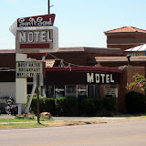
We drove out of the Grand Canyon North Rim past the towns of Jacub Lake, and Fredonia using 89A through the Vermilion Cliffs and headed on toward UTAH. Our next park was to be Zion National Park in Utah. After the cold nights (low 40s) at the North Rim and camping through the Grand Canyon we were ready for a bit of comfort. We found a small, out of the way motel called the Sun and Sands Motel in the town of Kanab, checked the rooms for cleanliness and decided the price was right and what the heck we could stay two nights for the price of one. Not only was Sun and Sand affordable, but the friendly manager Wayne, was knowledgeable about the sights in the area.
After a bit of research, we realized there were many places we wanted to visit in UTAH. Utah has many areas and acres of land designated as National Parks. Confusingly the name usually has “canyon” in it, in fact we found Zion National Park was also referred to as Zion Canyon and contained an area called Kolab Canyon. Then there was Canyonlands National Park and Red Canyon, Moab, Arches, Natural Bridges….too many to name, much less figure out a route. Well, tomorrow’s plan would be Zion National Park.
ZION National Park
In Zion, park elevations range from 3600 to 8700 feet on the Colorado Plateau, and so provide many different habitats for many different critters; tiny pinon mice, golden eagles, mountain lions have their niches. As we heard at the Grand Canyon, there are Condors nesting above the canyons, as well as Peregrine Falcons. There are areas of Ponderosa pine, Aspin, cliffrose, a lovely pink bloom, and mesquite. The trailheads to the rim environment, into the canyons and along the Virgin River allow heartier humans to immerse themselves fully into the exploration. Zion’s special formations are water formed due to freeze, thaw multiple times over time and river erosion. Because parts of Zion have been used in the past for grazing and farming this park is not “pristine,” but still has a lot to offer.
We entered the park, with a short line of other cars, from rt. 89 and traveled rt. 9 to the East entrance. In Zion there is a 15 mile road heading north on which tourists (like us) take a free shuttle bus to visit the eight river-carved viewing areas through the bottom of the Zion Canyon. The canyon walls become higher and higher as the bus moves slowly to the Virgin River and the Narrows riverside walk.
Returning to the car and the main road, just outside the park road to the west, are restaurants, hotels, and gift shops selling native crafts and other souvenirs. We drove through the area, stopped and checked out the birds at a very nice town park rested on a picnic table for awhile and continued on another 80 miles on Indian land to Kolob Terrace Rd. to Lava Point and Blue Springs Reservoir where it was too muddy to 4x4) wanting to move away from the crowds.
It worked. We needed the 4x4, but the red, dirt road was well maintained. It passed through private farms outlined with fences and over cattle guards (metal road grates to prevent free-ranging cattle from leaving their usual area), high onto the plateau above Zion Canyon. We kept on on the private road and found the Blue Springs Reservoir where the locals fish, camp and cruise in small boats.
Here are some pics from Zion. These pictures are from Dan’s camera. My battery was dead; one of the drawbacks to camping.
 |
| Zion National Park |
We were lucky to have our options in transportation. Sometimes we found too late that we shouldn’t take the bike to some of our destinations. Today, according to Wayne, was one of those times, we would be on dirt roads, so we headed to the Pipe Spring National Monument by car on rt.389 finding ourselves going through a time warp as well as a one hour time change and back in Arizona -on land managed by the Kaibab Band of Paiute Indians.
The visitors’ center was staffed by casually-dressed Paiute tribe members, as opposed to the usual green formal ranger gear we had become accustomed to. We absorbed information about the pre-Paiutes, the later Mormon settlers and the use of this important water source area as a frontier fort as well as a Mormon tith farm.
PIPE SPRING National Monument
Paraphrased from visitor literature
The area of the Arizona Strip, located between the Grand Canyon and Vermilion Cliffs has limited but important water resources. The groups known to have been located in this area were the Ancestral Puebloans until about 3000BC the Paiute Indians until the 1700s, when missionaries and explorers like Jacob Hamblin 1858 and John Wesley Powell in 1870 visited the area. Mormon settlers from Salt Lake City settled and farmed the area before and after that time. Water, the Spring, being crucial to the before friendly Indians, caused the Fort to be built in 1868 by the Mormon Militiamen. In 1870 Brigham Young and Anson Winsor paced off the new ranch that would be built as a tith ranch (at that time Mormon farmers gave 10% of their livestock to the church).
Later , about 1890, the Park Ranger guide in the “Winsor Castle” explained to our small group, how the wives and children of polygamists were often hidden from Federal Marshals to avoid testimony against their husbands.
By 1907 while the farm was still privately owned, the Paiute Reservation was formed around it. Water rights problems continued long after. The Paiutes could not find enough game to live and Mormon settlers all over Utah were displacing them from their traditional gathering and farming lands.
In 1916 the National Parks System formed. Steven Mather, the first National Park Administrator, saw the value in the Pipe Spring area as a rest spot for Americans who visited the Canyons Parks and acquired it for the National Park System. A railroad brought the tourists and In 1923 President Warren G. Harding signed the Proclamation to preserve Pipe Springs as a National Monument.
The story of acquisition of other National Areas with the laudable goal that these special “highlights” become part of the heritage of the United States seem to be similar to the issues at Pipe Spring. The road maps show reservation lands for the various Indian tribes. At the time the new land possession model must have been incomprehensible to the tribes involved.
As you enjoy the slideshow below, please pause to read the two views of “Land Management” that illustrate differences in philosophy between the two groups –Paiute and Mormon settlers led by Brigham Young- understandably causing tension.
Then we're back to the Grand Canyon-narrative below the slideshow
 |
| Kanab, UT, Toroweep Rd. to GC |
In Kanab the next morning at the included breakfast, great coffee, bread, donuts and muffins and fruit, we met a couple who had taken the road to Toroweep, another access to the Grand Canyon, and raved about the 65mile trek in their Toyota Tacoma. Wayne also recommended we not move on without visiting Tuweep-the Indian name for the area. Well, why not, we agreed and off we drove, again in the Subaru.
Toroweep Road and back to the Grand Canyon ( the “less traveled” road..)
LOTS MORE UTAH TO COME!


No comments:
Post a Comment